I've given a talk in December 2022 and am scheduled to talk again in January and February 2023 to groups comprised mainly of older homeowners concerned about lack of transit and wheelchair-accessible housing in their communities. Most are unaware that those are connected.
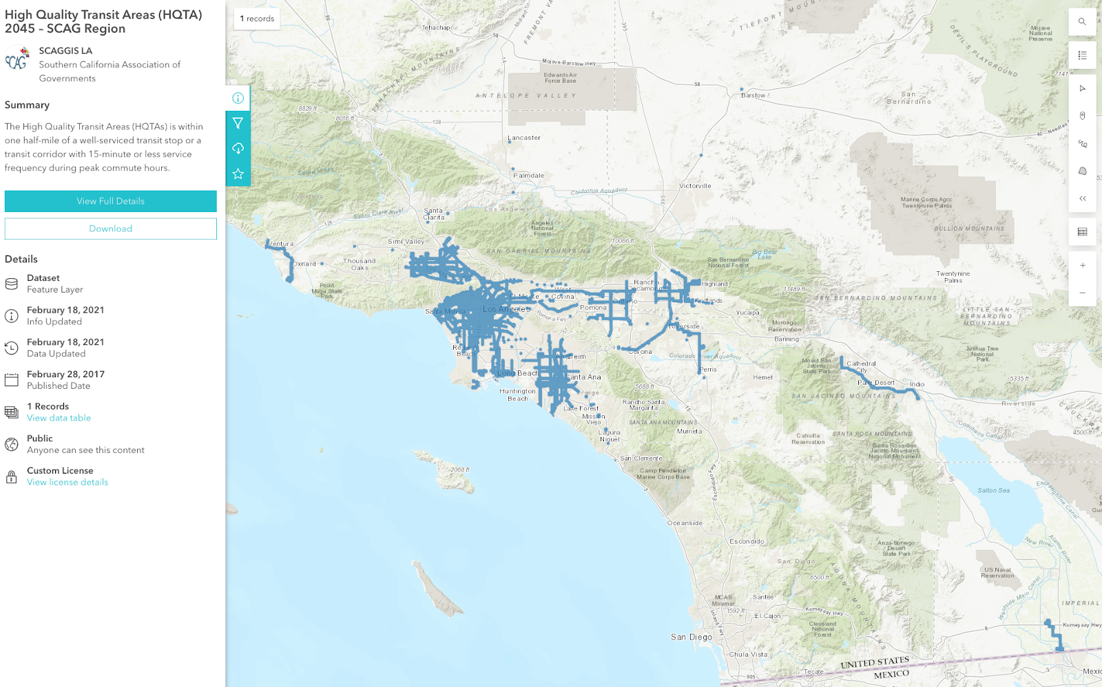
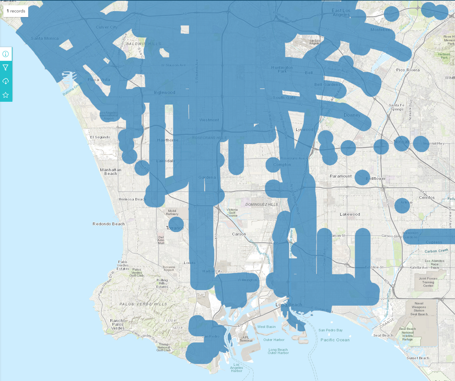
This is a GIS layer map of High Quality Transit Areas (HQTA) in the 6-county area under the control of the Southern California Association of Governments (SCAG).
The High Quality Transit Areas (HQTAs) is within one half-mile of a well-serviced transit stop or a transit corridor with 15-minute or less service frequency during peak commute hours.
Founded in 1965, the Southern California Association of Governments (SCAG) is a Joint Powers Authority under California state law, established as an association of local governments and agencies that voluntarily convene as a forum to address regional issues. Under federal law, SCAG is designated as a Metropolitan Planning Organization (MPO) and under state law as a Regional Transportation Planning Agency and a Council of Governments.
The SCAG region encompasses six counties (Imperial, Los Angeles, Orange, Riverside, San Bernardino and Ventura) and 191 cities in an area covering more than 38,000 square miles. The agency develops long-range regional transportation plans including sustainable communities strategy and growth forecast components, regional transportation improvement programs, regional housing needs allocations and a portion of the South Coast Air Quality management plans
Seniors want to stay in their own homes, or at least in their own communities. And they want frequent transit to serve them. They've looked around and are deeply unhappy with what they have found. Why can't we have frequent and good transit like other places they have vacationed at?
Why doesn't the South Bay have good transit? We're visibly a transit hole. High quality, frequent transit does not touch most of the residential areas of the Beach Cities, El Segundo, Torrance and Palos Verdes Cities.
Is it because wealthy people can afford cars and don't need transit? Nope, not if you compare to Santa Monica, Culver City, Pasadena and Beverly Hills.
When we purchased our home in the late 1990s, we researched bus lines, bike commutes and USGS geologic maps. We really liked that the Torrance 8 bus ran between our home, daycare, workplace at 30 minute frequency throughout the day and even more often during peak commute hours. Those buses were well-used by people who worked in El Segundo and lived along the route in Torrance, North Redondo Beach and Hawthorne.
Over time, the service degraded noticeably and wasn't reliable any more. That's the main reason why I ride my eBike during the day and drive at night. Transit isn't viable for me any more, even if I want to take a bus to dinner and then walk home (burn off dessert) or catch a ride home with my dinner companions. Even during peak hours, the buses are infrequent and often get canceled at the last minute.
I used the Internet Archive to look at bus schedules from 2005. The Torrance 8 ran 41 trips every weekday in 2005.
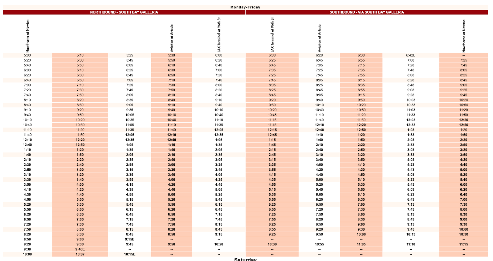
In 2022, the Torrance 8 runs only 13 trips every weekday.
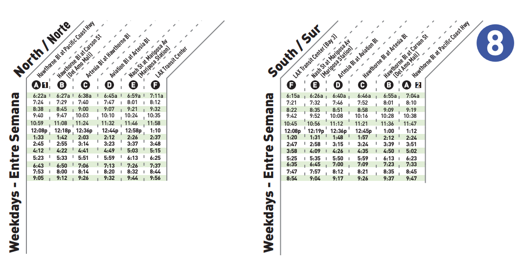
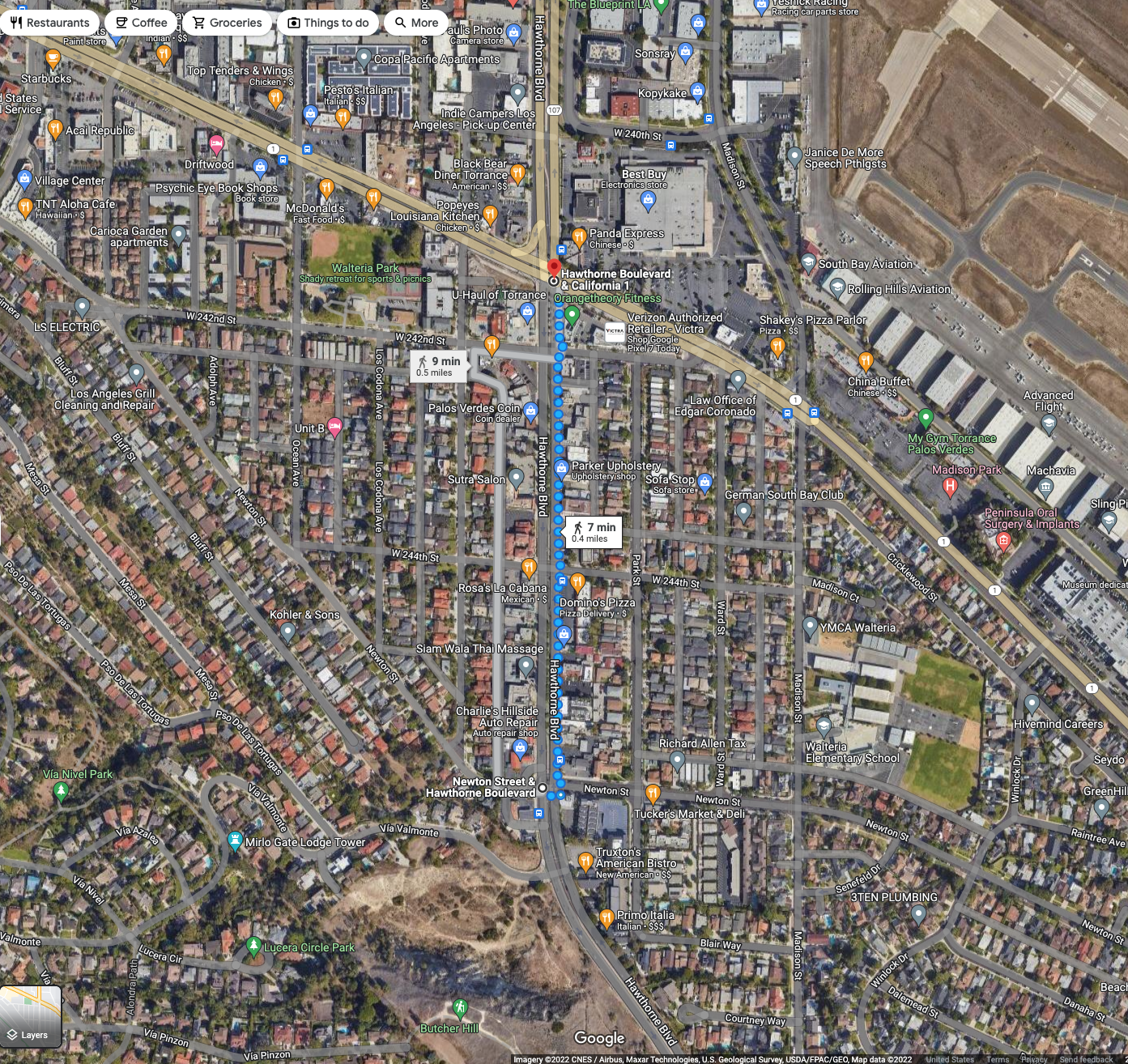
Moreover, the southern terminus of the route used to be at Newton St and Hawthorne Blvd, a short walk from hundreds of homes. Now the route has been shortened to end at the intersection of two state highways, Pacific Coast Highway (CA1) and Hawthorne Boulevard (CA107). To reach the stop, people have to walk farther from their homes and cross wide highways with 7-9 lanes of deafening traffic.
When I regularly took the bus, they were well-utilized. Most seats were occupied at peak hours. Even after peak, about half the seats were taken by people out shopping or going to their retail/service jobs.
Buses operate at a loss. That's why we pay taxes to subsidize them. But roads and parking lots also operate a loss and we never question whether or not they are necessary. Fuel and registration fees cover only about half the costs of roads; the rest comes from general funds.
The cost of "free parking" is borne by customers or tax payers, including those that didn't drive there. The subsidy is flowing towards drivers, not bike riders. In fact, pedestrians receive the lowest subsidy, then bike riders (cost of bike racks), then transit riders, then drivers.
But I digress. Let's get back to poor bus service. The seniors I talk to all want frequent buses that run near their homes. They would prefer the buses to run past their existing homes, but are willing to move to a condo or apartment complex within their communities if that is the only way they will get high-quality transit.
Sounds good. Let's pick some areas to serve intensively with transit, and then build lots of homes there. The more transit riders there are, the better service we can maintain; it's a virtuous cycle that serves seniors aging out of driving well.
Not so fast, building housing is politically toxic throughout the southland. Today's seniors have elected (for decades) local leaders running on platforms of preserving the "neighborhood character" of their "unique community", and fighting "overbuilding" and "Sacramento overreach".
Elected leaders are suing the state of California about whether they should be exempt from state housing law (like the Housing Accountability Act) and questioning both the legality and the numbers in the Regional Housing Needs Allocation.
The State of California's Department of Housing and Community Development (the CA analog of the Federal Government's HUD), tells each regional planning authority how many homes their region needs to build to provide for existing and future residents. Each region decides for themselves how they want to allocate those homes based on their goals and values.
After years of considering data and testimony from academics, elected officials, planning professionals and advocates for hundreds of groups, SCAG approved a formula nick-named "The Coastal Plan". It's just a formula that can be programmed into an Excel spreadsheet macro. You can download it from SCAG, and I've made it in to a shared Google Sheets.
The formula is a product of our professed values. We claim to value opportunity, so we assign more housing near where the jobs are. We claim to value clean air and want to lower Greenhouse Gas (GHG) emissions, so we place homes in HQTAs. We claim we want to address inequality, so we assign more low income housing to places that traditionally have not provided lower income residents.
Conversely, it assigns more higher income housing in poorer communities that can benefit from the tax base provided by higher earners. It's not forced gentrification or ghettofication. It's just trying to level the playing field to help everyone succeed. The goal is to work together with neighbors to solve regional problems like pollution, congestion, and the housing crisis.
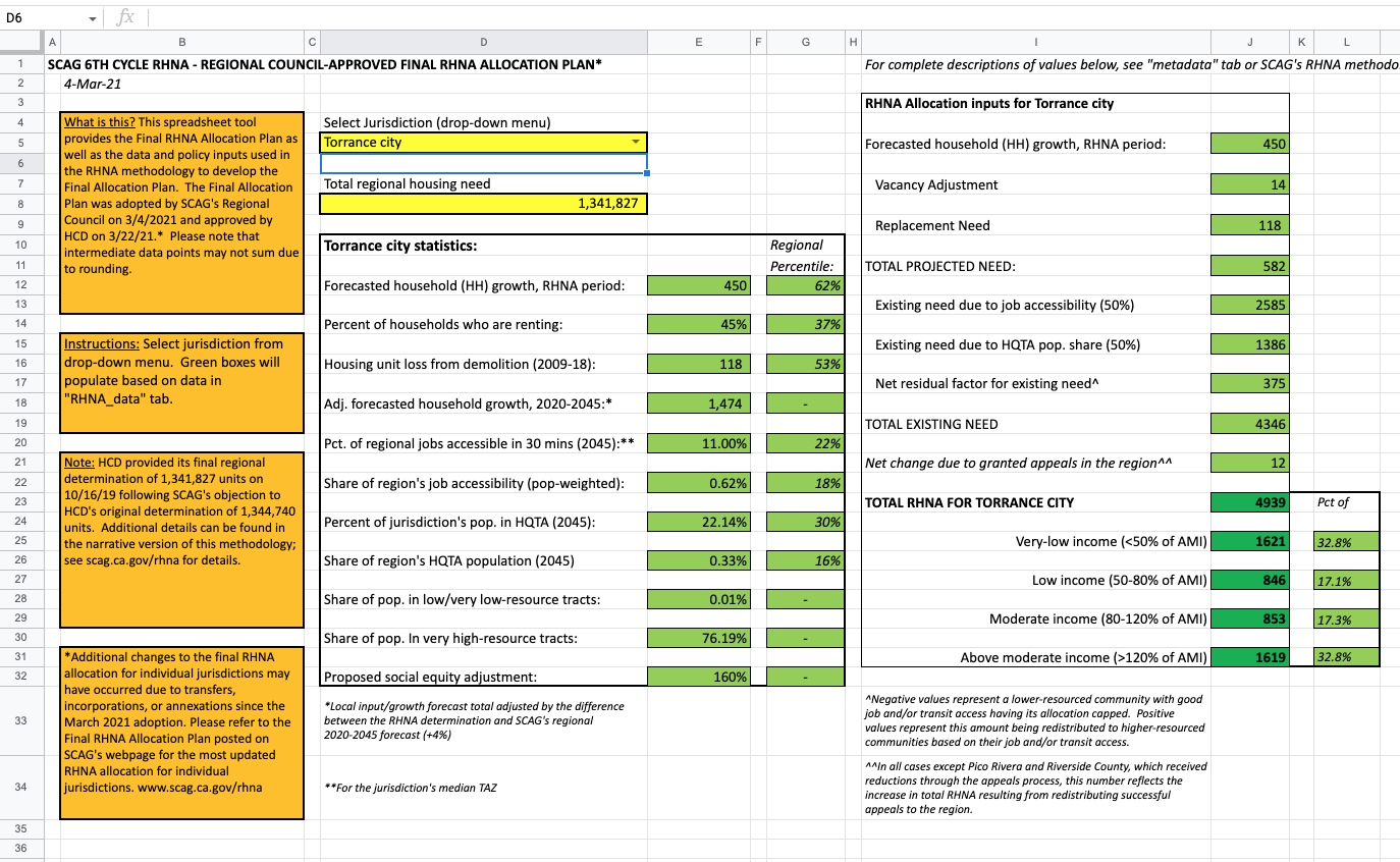
Just select your city of interest in cell D5. Here's Torrance, the city that runs Torrance Transit and presided over its demise. Torrance is big mad at their 6th Cycle RHNA "quota" of 4,939 homes over the next ~8 year RHNA cycle. They have never been given such a high allocation before. Their 5th Cycle allocation was 1,450, and they didn't even meet that.
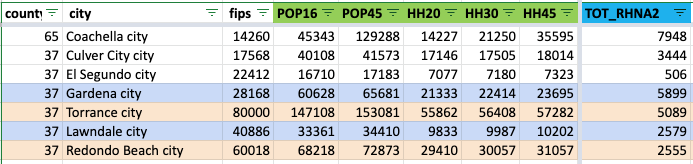
I paired Torrance with their neighbor, Gardena; and Redondo Beach with neighboring Lawndale. Notice how the smaller cities are given higher RHNA allocations than their larger and more affluent neighbors. They are assigned 2-3x as many homes per capita.
Is it because of job access? Look at the SCAG GIS map of Job Centers. Torrance is smack dab in the middle of one of the largest job centers in Southern California, with ~129,000 jobs.

Let's look at the HCD Affirmatively Furthering Fair Housing (AFFH) Data Viewer, the Jobs Proximity Index layer.

Both loudly-complaining cities, Torrance and Redondo Beach, have more jobs and easier access to jobs than Gardena and Lawndale, hence they were assigned more homes in the Jobs column.

What explains the big differences then?
Go back and look at the HQTA map. It's all based on existing population in the HQTAs within each jurisdiction.
The more people already living inside the existing HQTAs used in the planning formula, the higher their HQTA-based RHNA allocations. Most cities like jobs (with the possible exception of pre-pandemic San Francisco) so they don't play as many games with that.
Cities know that the way to finesse lower RHNA housing allocations is to minimize the areal coverage of HQTAs in your city, and then to minimize the number of people who live in the HQTAs.
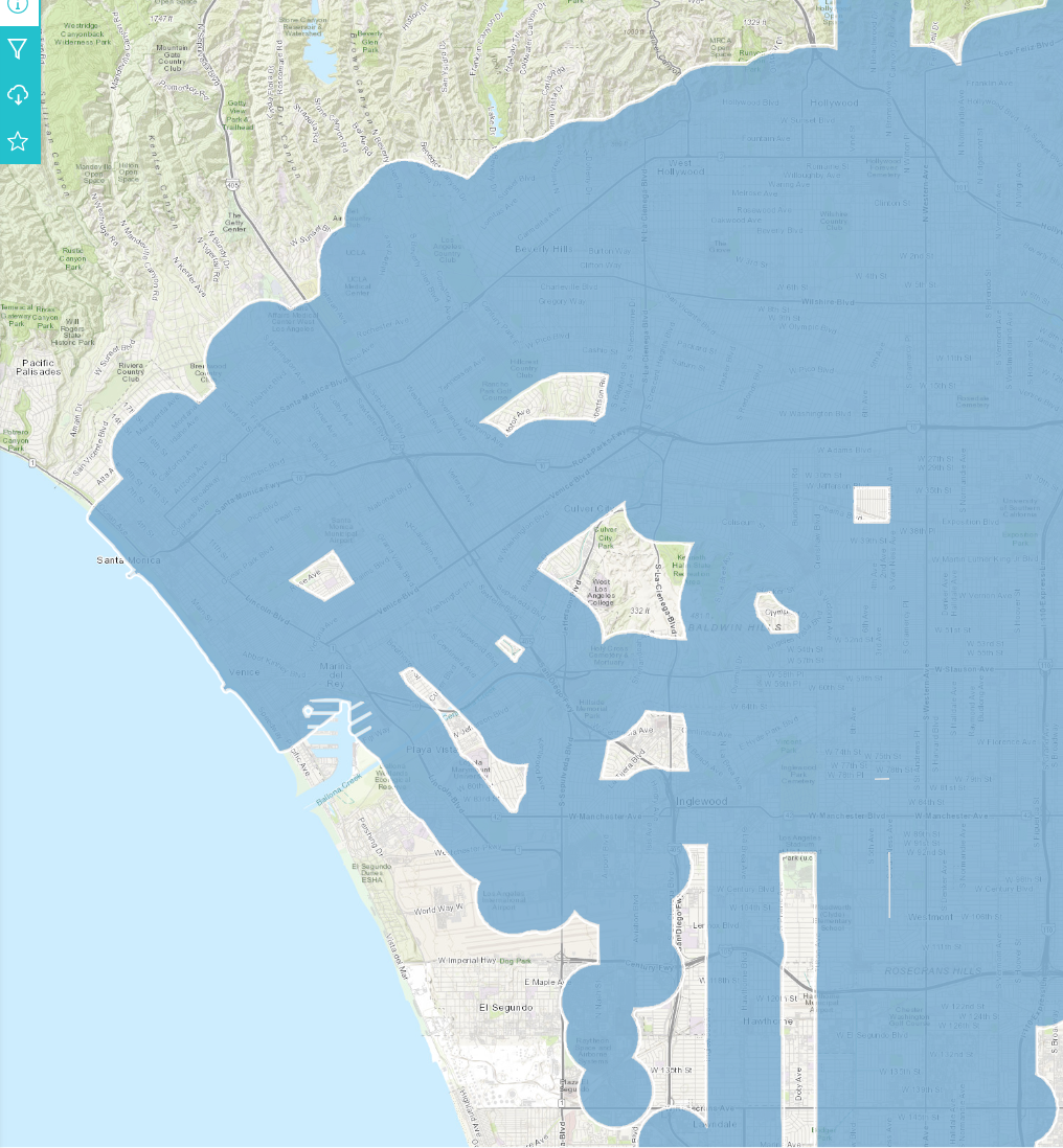
This is how El Segundo, home to LAX and the 121,000 jobs in the LAX job center,

and with 3 light rail stations inside of their cities and one just over the border at LAX, got allocated just 1 home due to HQTA. Yes, just 1 home!

When El Segundo fought to avoid permitting homes east of PCH, this is the subtext. They gave up land to Hawthorne to avoid having homes in their jurisdiction near a rail station.

It's all connected to the decisions made by the people we elected and the incentives they operate under. When they talk about preserving the "neighborhood character" of your "unique community", and fighting "overbuilding" and "Sacramento overreach", they collect donations and win elections.
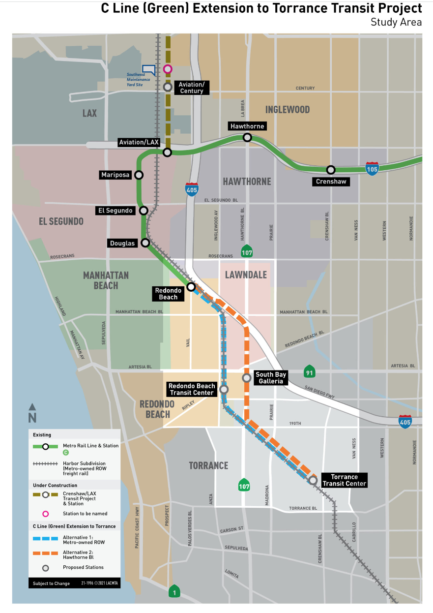
They don't tell you that they will never allow expansion of HQTAs within their jurisdictions if they can help it. This is a large part of the subtext of the fight over Metro C line extension routing. Your elected officials are fighting to ensure you don't get access to rail transit (which is harder to cancel/decrease than bus lines) so that they won't have to build housing.
They don't even want to build in existing HQTAs lest it expose them to higher RHNA allocations in future cycles. So instead, they talk about shadows and view sheds, impose high parking minimums. These all serve to reduce the number of homes that can be built and the number of people in the homes.
They don't tell you that the kind of low-density zoning they are protecting will only every yield townhomes with stairs, built on top of car garages. Low density zoning and height limits makes building accessible apartments with elevators prohibitively expensive to build. They hope developments don't "pencil out" (can't be built profitably), so that the developers go away.
What homes do get produced will be very expensive because they have to cover the parking and land. If you can build 2 stories of housing over 1 story of parking, they have to charge a lot more than if they built 4 stories of housing over the same parking structure on the same land. To maximize affordability, they could even stop requiring parking since seniors and the disabled are much less likely to drive or own cars anyway. Parking is another proxy war to suppress housing.
If you want to solve a problem. then you solve the problem. You don't spend decades screaming the problem doesn't exist. You don't enact ordinances that make the problem even worse. You don't sue people who point out that the problem exists. You don't defund researchers who collect data and evidence on the problem.
This applies to climate change and our regional housing crisis.
Enough, tonight. I just want to point out that it's all related.
Enjoy the Metro C Line (Green) Extension to Torrance Project Simulation Video. Think about how you want to live as you or your parents age out of driving. Think about where you want your children and grandchildren to live as the planet gets hotter and hotter. Do you want them on the cooler coast with you? Then make room for them.
Aside:
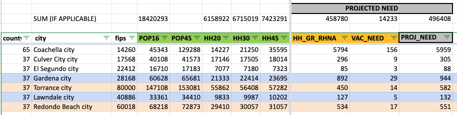
Coachella has 14,277 Households in 2020, while Culver City has 17,146. Yet, Household Growth in Coachella is projected to be 5,794 while Culver City's is only 296. That's a 20-fold difference!
No comments:
Post a Comment
Comments are open for recent posts, but require moderation for posts older than 14 days.