Showing posts with label Free Range Kids. Show all posts

Saturday, April 12, 2025

Motonormativity 2

I wrote an LA Voter newsletter (for members of League of Women Voters in Los Angeles County) article about Motonormativity and the way that local, state and federal governments reinforce it with their laws and actions. 

Professor Ian Walker wrote in the 2023 paper, Motonormativity: how social norms hide a major public health hazard, “Decisions about motor transport, by individuals and policy-makers, show unconscious biases due to cultural assumptions about the role of private cars - a phenomenon we term motonormativity.” 

His results were replicated in in the US by Professor Tara Goddard in the 2024 paper, Windshield Bias, Car Brain, Motornormativity: Different Names, Same Obscured Public Health Hazard. 

Past WIG speaker and public health researcher Isabella Chu, MPH, also spoke about the hidden public health hazard that is the top killer of US children. Indirectly, through air pollution and involuntary inactivity by making active transportation (walking, cycling) dangerous, cars may be the top killer of people in the developed world of all ages. 

Transportation, mainly private automobile use, is the largest contributor of CO2 emissions in Los Angeles County and the largest source of PM2.5 pollution (except in the occasional years when particulates from wildfire smoke affects populated areas of LACO.) 

Yet, all this is invisible to most people and especially law and policy makers. In California, it is legal to kill with a car as long as you were not intoxicated, were not speeding, and stayed at the scene of the death. This applies even if a driver kills a cyclist in a crosswalk

ILO wrote a letter to Metro’s Board of Directors for omitting protected bike lanes on the Vermont Ave BRT (Bus Rapid Transit) project plans. The City of LA’s Mobility Plan 2035 (adopted in 2014) promised to address identified shortcomings by 2035 by implementing the plan as each section of the roadways had work done. The Mobility Plan showed Vermont Ave would receive both a protected bike lane and a bus priority lane. 

Vermont Ave is infamous as more people die on Vermont Ave due to traffic violence than in the entire state of Vermont every year. (This does not include deaths due to pollution and other indirect deaths.) The LA Times explained the situation in Lawsuit filed against L.A. over lack of bike lanes, claiming Measure HLA violations

Local actions are even more important as we can no longer count on the Feds to help us. Under the Reagan Administration, Federal transportation dollars were allocated in a rigid formula of 80% to highways and 20% to transit. 

The Secretary of the Department of Transportation is Reality TV and Fox Business personality, Sean Duffy. He made headlines recently when he rode the NYC subway with NYC mayor Eric Adams and subsequently told Laura Ingraham on Fox News that "even big men don't want to ride the subway." 


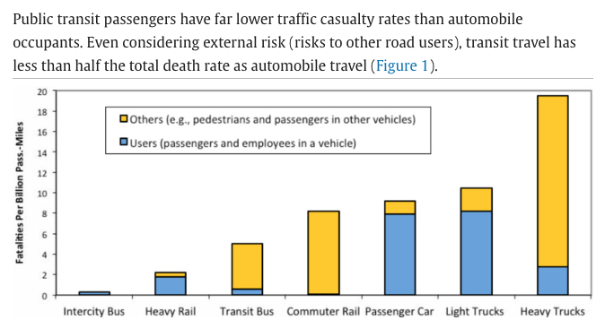
“Most transit trips include active transport (walking and/or cycling) links, and transit users tend to walk and bike more in total than motorists (Lachapelle et al. 2011). These modes have relatively high per-mile casualty rates, although this risk is largely offset by reduced risks to other travelers and improved public fitness and health, so per capita crashes tend to decline and overall health and longevity increase with more active travel in a community (Rojas-Rueda et al. 2011).” 
Transit is so safe that a 1% increase in transit mode share would result in a 2.75% reduction in road deaths. 

State lawmakers show similar characteristics of motonormativity. Until September 6, 2023, Californians could purchase EVs (electric cars) secure in the knowledge that they would receive guaranteed rebates of up to $7,500 for each EV, and that these would stack on top of Federal rebates of $7,500. The income cap was $200,000 for joint filers. California passed out over $1 Billion in EV rebates. 

Contrast that with the California eBike incentive, which has an income cap of $61,320 for a family of 2, and which exhausted the entire $10 Million allocated to eBikes within minutes. eBikes received only 1% as much money as EVs, despite global research showing that dual-mode households drove 19% less than before they obtained an eBike

 “Transportation is a climate and feminist issue. CA DMV data shows that women will spend twice as many years aged out of driving as men. Yet, our cities have not built infrastructure for people who don’t drive. 
… Car dependency is not just ruinously expensive, but it’s destroying the planet, and preventing nondrivers from fully participating in society. Women, as primary caregivers, are paying the time tax of chauffeuring people around. Protected bike lanes are mobility lanes, suitable for children on bicycles and seniors on mobility scooters alike.   
Local government decisions have kept us isolated and stressed.”

Wednesday, May 10, 2023

Guidance for the Metro Active Transportation Corridor: Redondo Beach Blvd Survey from a Local

Urgent Action Alert 

Deadline Extended to May 30, 2023 May 15, 2023 so read on and fill out the survey now 

I need you to fill out a public input survey about a vital active transportation project for Redondo Beach and surrounding cities in the South Bay region of Los Angeles County. This is our chance to reverse some of the damage wrought by past auto-centric road design in North Redondo Beach and allow those who can ride a bike to make school and shopping trips with confidence that they can make it home alive and in one piece. 

There's also a Story Map about the Redondo Beach Blvd Active Transportation Corridor Project with more information. 

Short version if you are in a hurry:

The current street allocation with car parking on both sides and massive SUVs speeding down our streets is not safe or welcoming for cyclists. The proof is in the declining bicycle mode share. 

When filling out the survey, select the options that give a protected bike lane every time. Scroll down past the background info to see my recommendations and why. 

Paint is not protection. Never select an option with a paint-only bike lane in the door zone. If someone opens a door, a cyclist in the door zone will be knocked off their bike and suffer grievous injuries. If they swerve to avoid the door, or are knocked into the traffic lane, they could be killed. No one wants to be killed or have their child killed while riding to school. 

Two-way cycle tracks are a good option, particularly near schools. When kids are arriving or leaving school, there will be a lot of traffic congestion on all modes. But cars are particularly dangerous. The less car traffic they cross while leaving the congested area, the safer they will be. Keep them on the school side of the street, with wide lanes so that there is passing room in the bikeway (keep the kids out of the car traffic lane). 

Plastic poles are not physical protection, but likely the best we can get as a first step.  Plastic poles can be replaced with bollards or concrete barriers later if we allow enough buffer space to install the plastic poles in the first place. Do not let the perfect get in the way of actions we can do right now. 

You can skip the background (but I hope you read it when you have more time).  

Background: The Connection with Schools

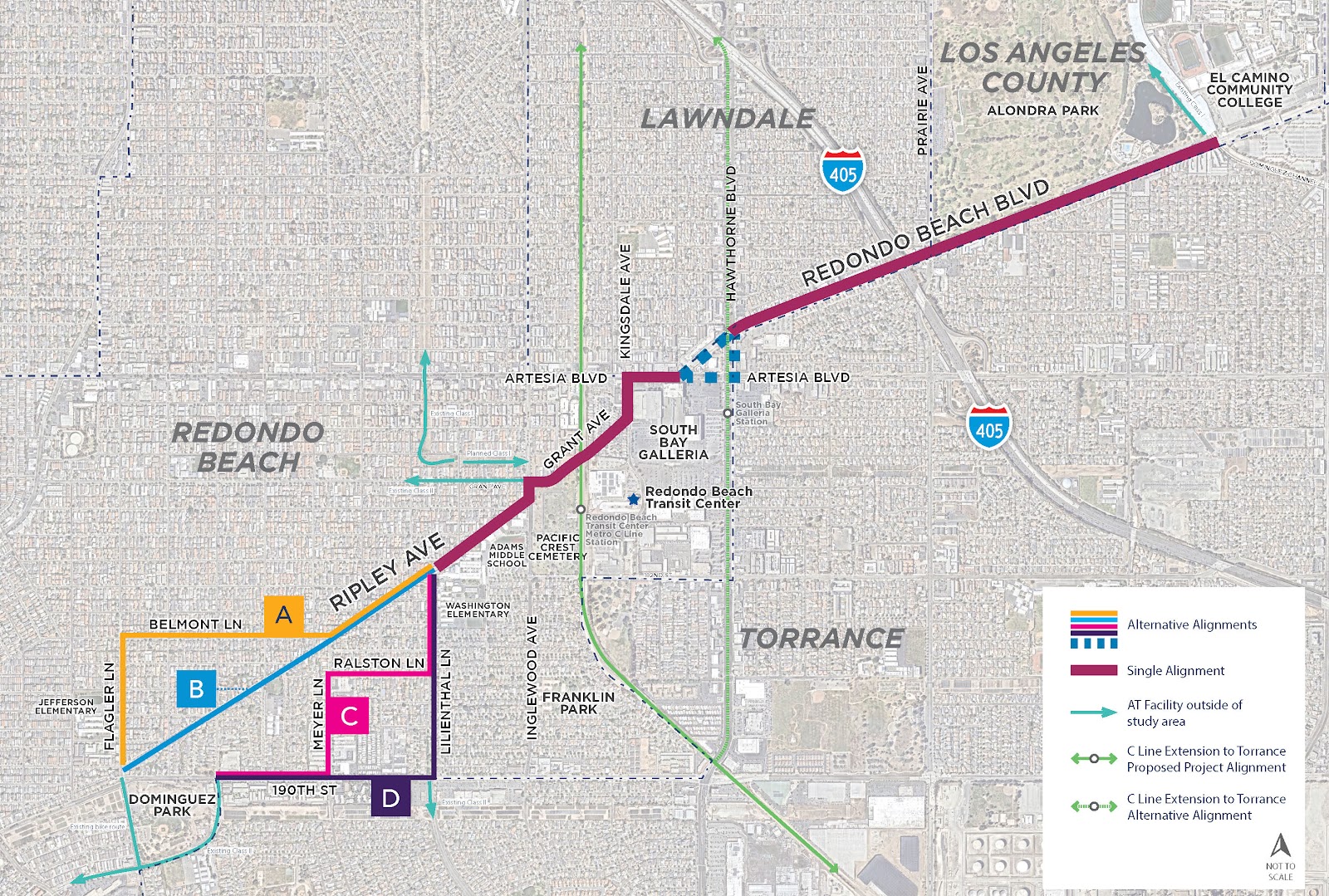
The project area below was originally going to be along the old freight route from Redondo King Harbor to the inland rail routes, but Ripley was found to be too steep (several areas with 15% grades) to be feasible for safe cycling. 


A Redondo Beach traffic study determined that 30% of the city's AM/PM peak traffic is the child school run. This travel corridor includes

  • Adams Middle School: 1066 students: 6-8 grades
  • Washington Elementary School: 801 students, K-5
  • Jefferson Elementary School: 509 students, K-5
That's almost 2400 K-12 students arriving and departing each day on this corridor. 

But that's not all, because all students in Redondo Beach Unified School District (RBUSD) attend Redondo Union High School (RUHS) in South Redondo Beach*. Jefferson ES students also attend Parras Middle School south of RUHS. 

Assuming 350/grade at Adams MS and 90/grade at Jefferson ES, 

350*4 + 90*7 = 2030 students cross 190th Street to attend school and return home each day. 

About half of all RBUSD students traverse this corridor every school day.

But that's not all; El Camino College (ECC, 22,000 students, many from the Beach Cities) is on the eastern end of this travel corridor. Some RUHS and MCHS students do concurrent enrollment and take classes at ECC while they are in HS. Due to many factors, including cost and lack of housing at UC campuses, a large number of students are enrolling in grades 13/14 at ECC before transferring to a 4-year college/university. 

When filling out the survey, think about what you would send your kid to school on. Think about what you would be comfortable riding on as you accompany your younger child to school or run your errands. I ride this area 1-2x/week to run errands in North RB or West Torrance. I want better infrastructure for my safety, too. 

Watch this video of the horrifying existing conditions as ridden by two fit MAMILs (Middle-Aged Men in Lycra). Would you ride these steep hills? Next to fast-moving busy traffic?


Here's another video of the area where Kyle, an area father, rides his kids to preschool. 


My opinionated guide for the survey choices and why they matter: 

Every cross-section shown is facing either Eastbound or Northbound.

Q1: For the westernmost portion of the corridor, which alignment(s) do you prefer? 


I picked D because that would give us a 2-way cycle track on Lilienthal and the longest length of protected bike lanes on 190th. 190th St is also the only way to avoid steep hills. 

The problem with B: The first video shows just how steep Ripley is. Notice that the lead cyclist on a light road bike has trouble getting up the hill (and the trailing cyclist with the camera is on an eBike). Going up a 15-16% grade is difficult, but going down them is downright dangerous. Do not send kids on this route. 

A and C are better, but still steep in some sections. Also, if those are the official routes, there will not be likely any road changes except Sharrows, which are shown to be more dangerous than not doing anything

Only Option D along 190th St will yield any road space allocation for cyclists. 

What is a Sharrow? 

Why are Sharrows so dangerous? 

Q2: The proposed street section for 190th St (Alignments C and D) is shown here. How satisfied are you with this proposal?


I picked Very Dissatisfied: These cross-sections are looking towards the east, with Torrance on the Right Hand Side (RHS) and Redondo Beach on the LHS. Cars are coming down the hill from Flagler and often speeding 50 eastbound mph. People drive with the sun in their eyes during the morning and evening commutes. Do you feel safe with just paint and plastic poles designed to bend when run over by vehicles?

I recognize that people living in the apartments in Torrance on the right need overflow parking, but let's swap the bike lane and parking lane. Install a parking-protected bike lane like this one in Long Beach on the Torrance side with breaks to preserve sight lines at each driveway or street crossing. 


On the RB side, I'd like to see real bollards or a curb. Imagine something like these without the parking lane. Images courtesy of National Association of City Transportation Officials (NACTO)


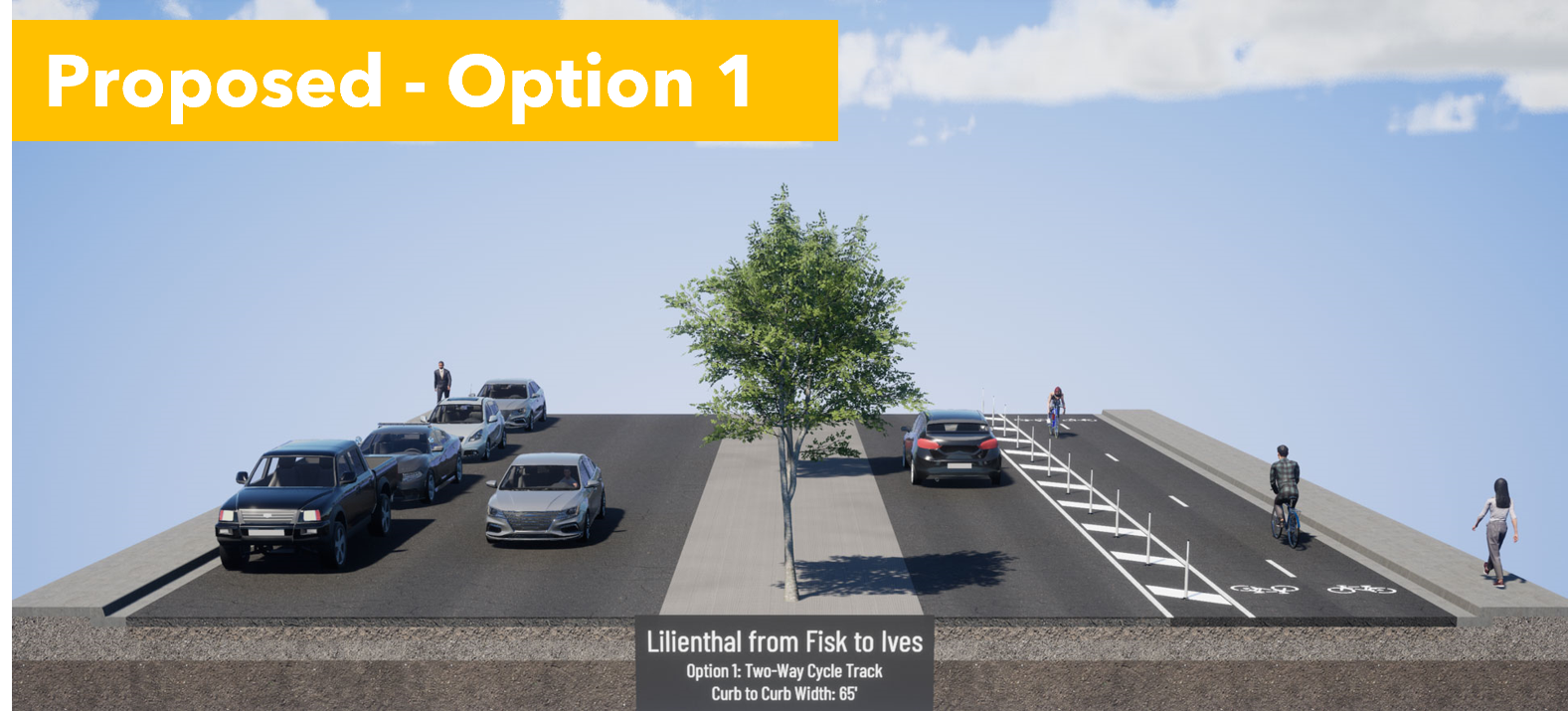
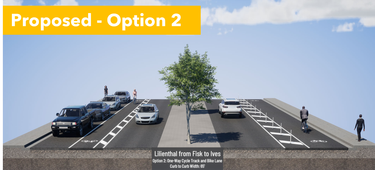
Q3: Select Option 1, the 2-way cycle track on the east side, next to Washington ES. 


Option 1 provides separation from cars, and is wide enough for passing, and allows parents to ride side by side with a child gaining confidence in their bike skills. In 2-way cycle tracks, people riding opposing car traffic are facing approaching cars, so they can see and react to dangerous drivers. It would be better to have solid protection here, but Option 1 gives us room to retrofit with more solid barriers later. 


Option 2 puts kids in the door zone on one side and makes them cross the street to get to school. It's a dangerous situation. 


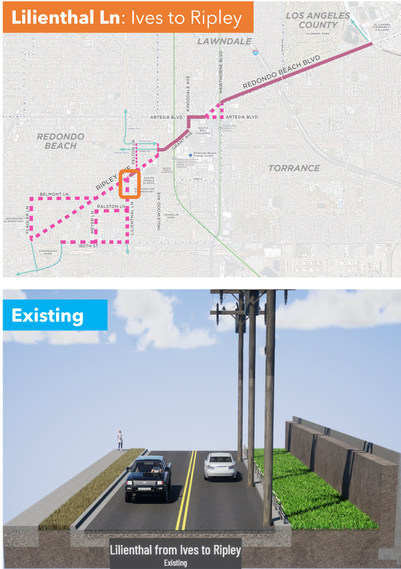
Q4: Select Option 1, the 2-way cycle track on the east side, next to Washington ES.  


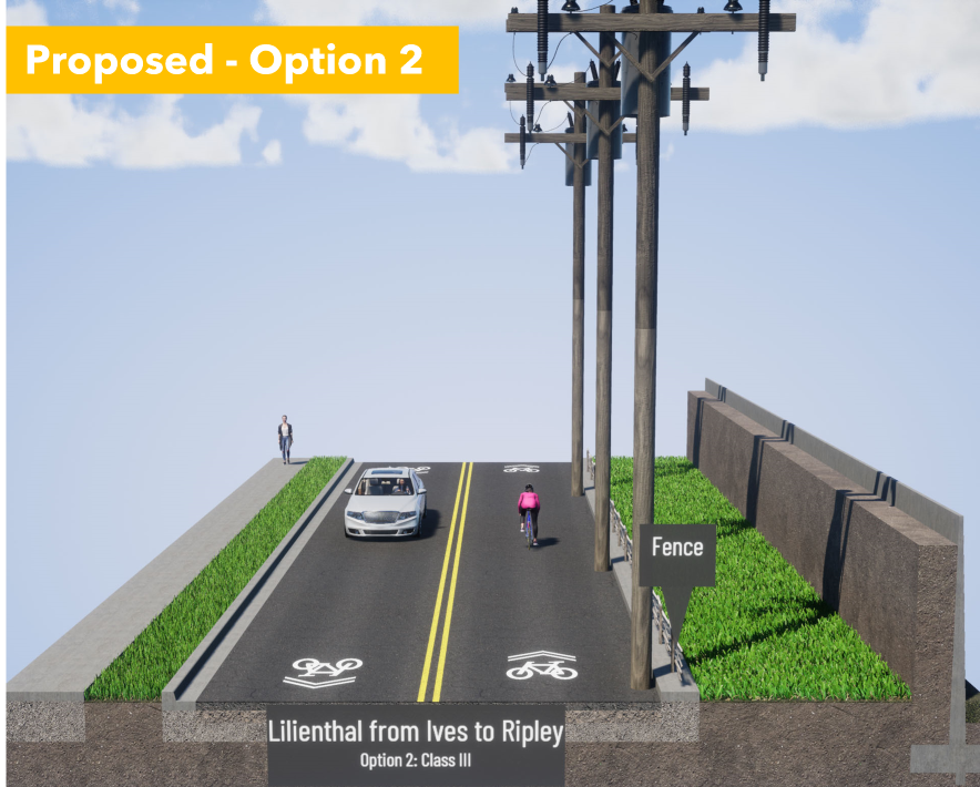
Don't be distracted by the stock visualization image with a tall solid wall. There is currently short solid wall on the parking lot side and a wood and rope fence on the road side. 


Option 1 gives a clear place for kids to ride that is physically separated from cars. The 2-way cycle track would replace the wide grassy area.


Option 2 is sharrows in a place where drivers are more focused on making a turn at Ripley than cyclists approaching from behind them. 

Motorists trying to make a right turn will pull over to the right, trapping cyclists behind them. Small children on bikes and tall, boxy hoods on todays trucks and SUVs mean that parents may not be aware of cyclists in front of them. This has led to an epidemic of frontover crashes where drivers run over people in front of them because they can't see them over their hoods. Or, they look at their screens and forget that there are children in front of them. 

Option 2, sharrows, is a safety disaster. 


Q5 on Ripley: Pick Option 1, the 2-way cycle track on the Adams MS side


Option 1 keeps the kids on the school side as long as possible. It also preserves the car unloading curb space that people are currently using. 


Option 2 puts kids in the door zone, at precisely the time that kids being driven to school are unloading. This is a safety disaster. 


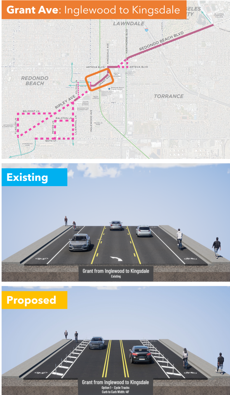
Q6: Grant Ave from Inglewood to Kingsdale; I am very dissatisfied but I selected other and explained why we need solid protection instead of plastic bendy poles


They are proposing paint, a buffered (space separation) and plastic bendy poles. 

This is better than existing conditions, but not safe. Cars pick up speed heading downhill and frequently misjudge the curve, so they end up sideswiping cyclists in the bike lane. We really need a concrete barrier on the downhill (right hand) side. 

I ride by bike to shop at the Galleria and this is the scariest part. I saw a guy almost get killed here. If we want more people to bike through this area, which connects to shopping, the South Bay Transit Center, and the 300 new homes under construction, then we deserve solid protection in this dangerous area. 

I gotta break for lunch but I'm going to hit Publish on this so you can get started. I'll finish after lunch. 

...

I'm back. Stay with me because we are on the home stretch, but the most dangerous one that crosses the 405 Freeway and has the most high-speed traffic. 

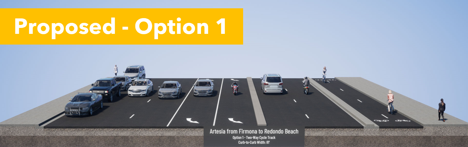
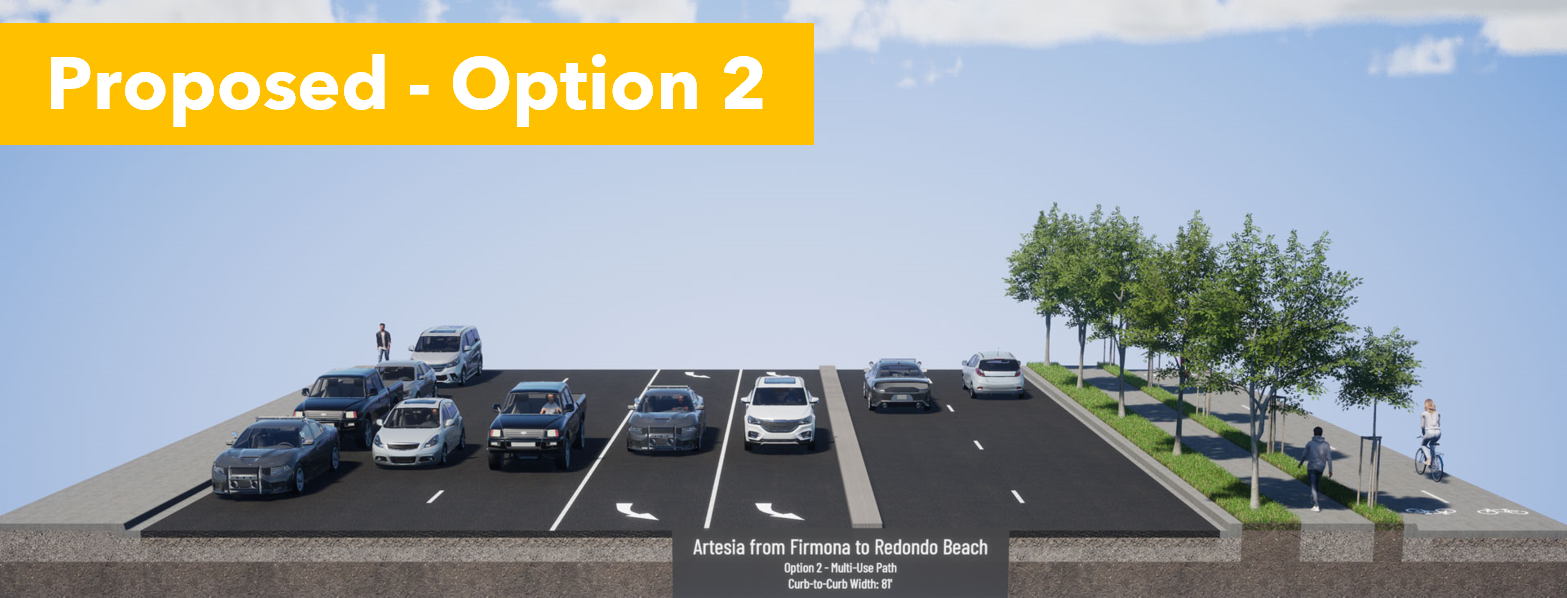
Q7: Artesia Blvd from Kingsdale Ave to Redondo Beach Blvd pick Option 2.  

Existing conditions are awful and you see very few cyclists brave enough to ride here. If they do, they are often on the sidewalk, conflicting with pedestrians. 

Option 1 puts cyclists next to vehicle lanes, but protected with a concrete curb. Pedestrians and cyclists would intuitively understand where they are supposed to be, as faster bike traffic is at the street level. However, this would interfere with bus stops. 


Option 2 puts pedestrians next to the vehicle lanes, but also next to the bus stop. Trees would provide shade. There could be some confusion with pedestrians wandering on the bike path, but that can be solved with good signage.


Our community has experience with pedestrian and bikeways next to each other in the North Redondo Beach Bikeway (NRBB). While there is some spillover, people have already learned where pedestrians and rollers have priority on the NRBB. Option 2 will work best for us and we already know how to use it. 

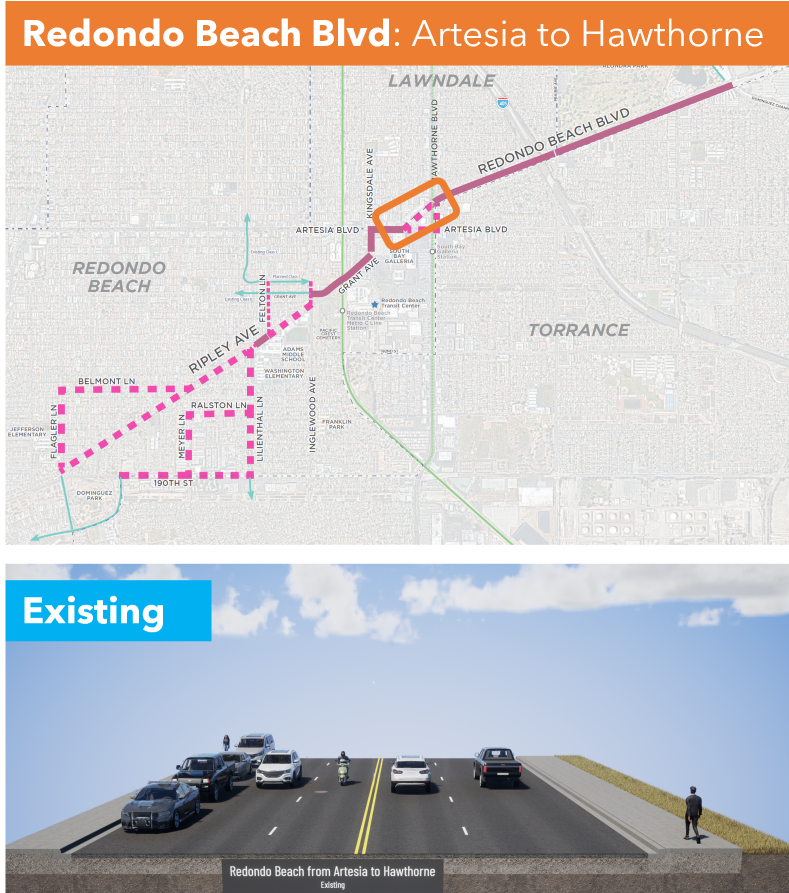
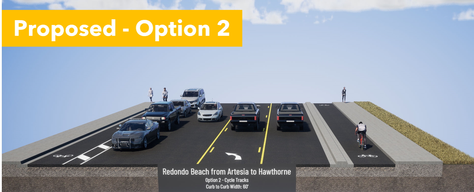
Q8: Redondo Beach Blvd from Artesia Blvd to Hawthorne Blvd. Is a tossup but both Options are so much better than the status quo.


Option 1 pits cyclists against pedestrians, but provides 2-way access to Walgreens and Starbucks. It's not terrible as long as cyclists slow down when passing pedestrians and motorists exiting the parking lots look both ways. 


Option 2 provides a clear separation between motorists, cyclists and pedestrians. Cyclists are curb-protected on the eastbound RB side, and parking-protected on the westbound Lawndale side. However, coming westbound from Walgreens/Starbucks, people will likely bike on the sidewalk until they meet the 2-way cycle track. 


Although you lose a traffic lane, it's not the cyclists' fault. One can just as easily blame the space allocated to free car storage (on-street parking) and a turn lane. Motorists are losing a travel lane to other motorists, not cyclists. Don't forget that. 

Option 1, the 2-way cycle track, provides a better alternative not suggested by Metro for the next section. 

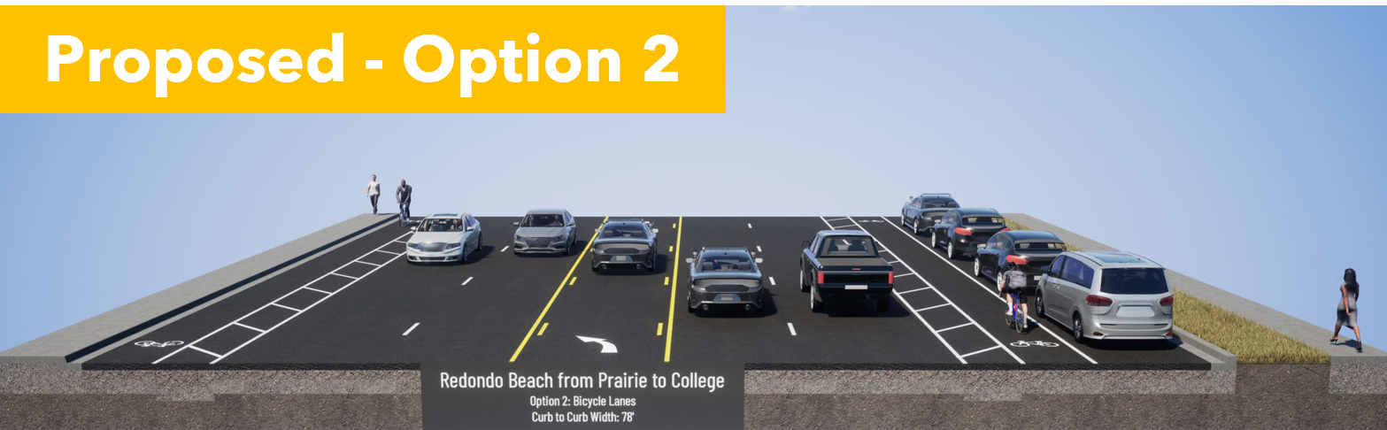
Q9: Redondo Beach Blvd from Hawthorne Blvd to Prairie Ave. I am Very Dissatisfied & propose a better solution. 


Although the status quo is very bad, we shouldn't rush into the proposed door zone bike lane next to high-speed traffic heading to the freeway onramps. It is extremely dangerous. This will greatly reduce the number of people brave enough to ride to Alondra Park and El Camino College. 

If there is enough room for on-street parking, then there is enough room for a parking-protected bike lane. That may require narrowing the car lanes a bit, but that would also inhibit speeding, making that stretch safer and quieter for all road users. 

The freeway onramp is on the north side of RB Blvd. A 2-way cycle track on the south side of RB Blvd would keep cyclists away from the crazy line of cars trying to merge onto the 405 on-ramp. Suggest that in Q11. 

Q10: Redondo Beach Blvd from Prairie Ave to Dominguez Channel. Pick Option 1, the 2-way cycle track on the North side, next to the park and El Camino College. 


Option 1 puts cyclists next to the park and ECC. Although it is shown with plastic bendy straws, it can easily be fitted with bollards or a concrete curb for better protection when cycling to and from evening classes at ECC. 


Option 2 puts cyclists in the door zone, where they can be knocked into fast-moving traffic and killed. Drunk or malicious drivers can also harm cyclists easily with only "paint as protection". 


Q11: Additional Comments: This is where we ask for a protected 2-way cycle track on on the south side of RB Blvd between Hawthorne and Prairie. 

What do you need to be comfortable bicycling this corridor? Tell them!

Keep in mind that younger Beach Cities kids will probably only ride the western side of this corridor, west of Inglewood or Kingsdale. But older teens and young adults may need to ride to ECC or to retail jobs between Kingsdale and Crenshaw. 

There are a lot of children and seniors in Lawndale and Torrance who would benefit from these bike facilities, whether they are riding a bike, trike or mobility scooter. 

We should make this corridor welcoming for ages 8-80. 

Think about who needs to travel through this corridor and at what times. What kind of cycling facilities do they need to get there comfortably and safely?  What about seniors in mobility scooters or electric wheelchairs? Would you like to see food delivery robots in the bike lane or more food delivery by privately-owned cars?

With better bike facilities, I may choose to bike to stores further east than I currently feel safe. Every trip I make by eBike instead of car, I am "sparing the air", not taking up road space in front of you, and not competing with you for parking. 

Another thing that excites me about this project is that it connects us to the Dominguez Channel. In a separate project, LA County Public Works will be extending the bike path along the channel southwards. It currently goes north to 120th St, past Amazon, Space-X, Lowe's and to the Metro Green/C Line. A southbound channel bike path would connect to the Harbor Gateway Transit Center, with very fast connections to the Silver/J Line to USC/Expo Park (15 min) and Downtown LA (20 min). Harbor Gateway TS is already linked up to CSU Dominguez Hills. This is a large step forward for a transportation transformation for the South Bay. 

Bike lanes benefit you even if you don't ride a bike, but your neighbors do. 

Bike lanes will save you time currently spent chauffeuring your kids short distances. 

Bike lanes will benefit your kids because students who get exercise before school do better. 

Bike lanes will benefit you when you age out of driving. 

Bike lanes may allow your family to shed one car, saving you over a million dollars per lifetime

Finally, I want to close with this terrific video of a #BikeBus led by Coach Sam Balto in Portland. 

https://twitter.com/CoachBalto/status/1656353963489501190?s=20

This bike corridor will touch the lives of half the students in RBUSD and can be transformative for the way our community gets around. If half of our households can shed just one car, we would be richer, our street parking and traffic congestion problems will evaporate, our air and water will be cleaner, and we will have done our part to slow climate change. Oh, we'll be fitter and happier, too. 

* A very few students living in North RB attend Mira Costa HS in Manhattan Beach, but only if MBUSD will take them. 

Monday, July 18, 2022

So your city has declared a climate emergency

 We are experiencing record heat in both North America and Europe, during a La Nina year (when the planet surface tends to be cooler than average).  The only way to stop this long-term runaway heating is to quit emitting so much CO2 and other planet-warming gases. Yet, our elected leaders, even in deep blue states, are not doing the necessary work.

I am so tired of fighting for substantive changes that I wrote about in Data Driven Climate Action. We know that 44% of LA County's GHG emissions comes from the transportation sector. If you add fossil fuel refining, it's over 50%. Over 2/3 of transportation emissions comes from private light-duty vehicles (cars, trucks, SUVs, minivans).  Much of those miles are "junk miles" in the sense that they are short trips that could be done without a car if the built environment were not so auto-centric. 

I have been a bicycling advocate since graduate school in the 1990s, when I was studying gas-phase chemical physics. We knew it was cars back then, and it's still true today. 

Global Atmospheric CO2 was 360 ppm (parts per million) when I volunteered for my first Boulder BikeWeek. 

CO2 was 367 ppm when I volunteered for my first El Segundo Bike to Work Day Challenge in 1998. 

CO2 was 369 ppm when I went to my first Beach Cities Bicycle Network Community Outreach meeting in 1999.  Community outreach took forever. My 21 year old daughter wasn't even conceived yet, which was why I had time to attend the meeting. 

CO2 was 392 ppm in 2011 when the South Bay Bicycle Master Plan was adopted. Cities pledged that they would add the bike lanes when they repaved or did work on any of the streets in the network. Over time, the network would be completed. A few cities did the bare minimum, striping in door zone bike lanes or stenciling sharrows when they repaved streets. Others, just ignored the plan. 


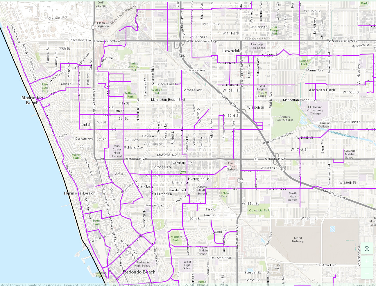
CO2 is 428 ppm in mid-2022.  Here are the existing bike lanes in the Beach Cities. Transportation planners are still expecting people to drive to the beach and ride along the Strand as recreation, not as every day transportation.


Here's the innovation in 2022. Those promised bike lanes will become a Local Travel Network, LTN, suitable for use by all sorts of low-carbon vehicles such as electric golf carts, eBikes, eScooters, motorized wheelchairs, skateboards, etc. They plan to start delivering this network in 2024. Notice how much less ambitious it is than the 2011 plan. It will not include anything other than sharrows and a few beg buttons at existing traffic signals. Unlike the 2011 plan, there will be no new traffic signals to allow cyclists to cross busy arterial streets. 

These purple lines are streets/roads where speed limits are 35 mph or less and are not truck routes. But notice how few of them cross the 405 Freeway or any of the high-traffic arterial roads/state highways. 

Not only are the legal crossings few and far between, necessitating long detours, but some of those purple streets are one-way. Going in the reverse direction will require an even longer detour. I can't make anything this ludicrous up. 

Consider the case of a student in North Redondo Beach who attends Mira Costa High School on an inter-district transfer. (The bus from North RB to RUHS in South RB is jammed and leaves kids stranded at the bus stop. To avoid this, some families beg for an inter-district transfer to the closer MCHS.)

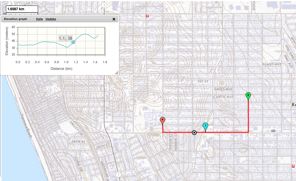
If they had delivered on a bike lane along Artesia Blvd when they repaved it, students could take a direct route with a maximum grade of 5%. Not super pleasant, but doable if you had a protected bike lane.  Of course there is no bike lane of any kind because that would have removed free on-street parking.  Which is more important than our kids' lives and planetary health. 

Direct route: 1.6587 km, max 5% grade

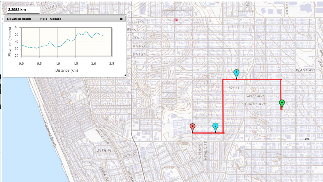
Instead, students must take a roundabout way to an existing traffic light at Robinson/2nd St. 

Westbound detour: 2.2982 km, killer 15% grade short hill

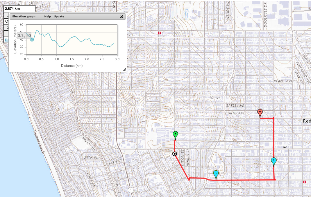
But Robinson is a 1-way street going westbound, and so is Plant, the only other street connected to the east side of that traffic signal. To get home, our student has to take a different detour that crosses Artesia Blvd (CA 91) twice and Aviation at an angled intersection. 

2.874 km, wheelie territory 15+% grade sustained climb

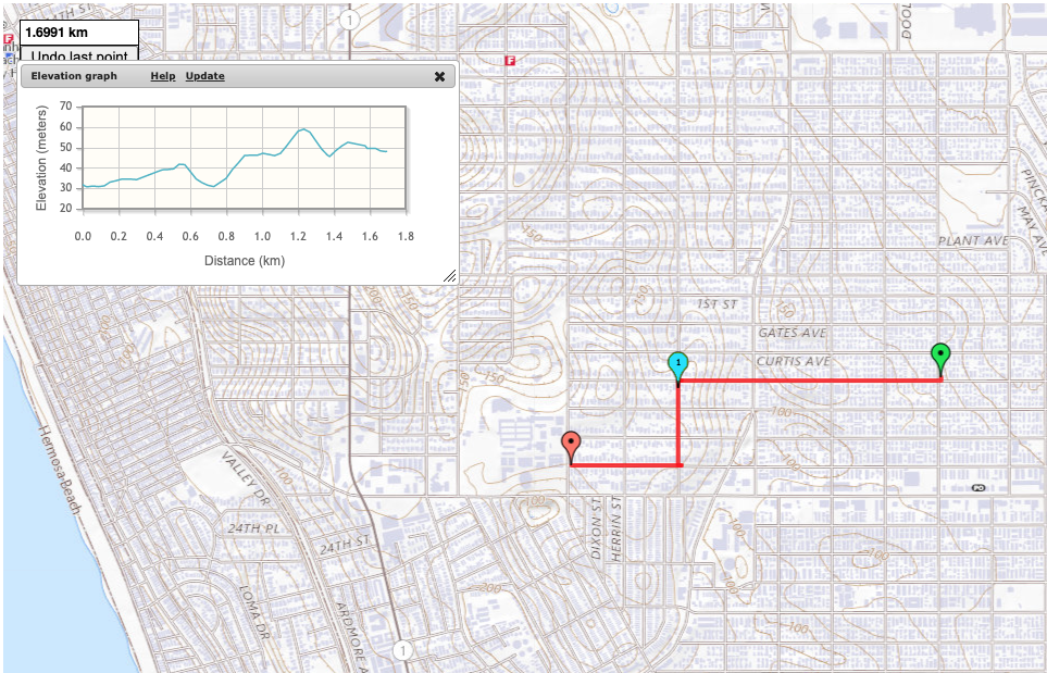
If they had built the 2011 Bicycle Master Plan, with a new traffic signal at Voorhees, our student would have had a reversible direct route. There's a 13% grade climb for half a block. But it's doable with an eBike or a very low gear or if they dismount and walk that section. 

1.6991 km, max 13% grade

(I used mappedometer.com in metric to make calculating grades easier. )

In what world do we expect people in an automobile to take a detour that adds 75% more length to their trip and steepens climbs from 5% to 15% grade? That's just abusive. 

It's late, so I won't dissect why kids are riding eBikes in all sorts of unsafe ways. Spoiler, it's because the streets are hostile and don't allow them to take more direct and safer routes. 

This LTN will not make any difference when completed. 

2024 will look a lot like 2022. Only CO2 will be higher still.  And we'll have more dead kids*. 

* "the crash may have been a result of misaligned crosswalks due to the single diagonal cut handicap ramp, rather than two separate ramps aligned with the crosswalk." 
I have written before about the danger of single diagonal curb cuts.

Sunday, April 04, 2021

LTN: One possible solution to decarbonizing transportation

Bad Dad and I were featured in A Local Travel Network for the South Bay Story Map* riding my Ebike and an Escooter we bought for combining with transit just before the March 2020 lockdown.


Click through to see the full wide picture that also includes a BMW electric car.  I have mixed feelings about this project.  I think it is a reasonable baby step, but the South Bay Cities Council of Governments does not appear inclined to offer more than sharrows.  In fact, their South Bay Bicycling Master Plan counts roads with 50+ mph traffic and a sign on the shoulder saying it is a bike route as a bikeway.

The Story Map makes some good points about the South Bay region of Los Angeles County.  This area is home to roughly 1 Million people and 750,000 cars.


70% of South Bay trips are less than 3 miles, yet we do most of them by car. It's both a problem of habit and the built environment. We don't provide safe spaces for people out of cars, so people make trips in cars, even if they would prefer to do otherwise. Spend some time exploring pedestrian and cyclist data using UC Berkeley's Transportation Injury Mapping System


In 2009-2020, there were 100,000 collisions involving pedestrians and cyclists, including ~3100 deaths,  in Los Angeles County.


This is just the people that braved the streets outside of cars. This doesn't even represent the suppressed active tranportation trips that people took in cars or forwent out of (quite rational) fear.

I'll take allies where I find them.  I am accepting the LTN (if they actually build it) as a down payment, but not as payment in full, for the safe streets that we deserve and need as we decarbonize local transportation.

* We were told to be near the intersection of Pacific and 10th street in Manhattan Beach, CA one Saturday morning to film.  We bike through that area on our way to the beach several times a week.  It's one of the most expensive neighborhoods in the region.  The organizer wanted a quintessential South Bay setting with the ocean.  But, I would not have selected a neighborhood that aggressively protects Single Family Home Zoning to preserve the affordability of $30,000,000 ($30 Million) dollar homes.  We have to quit showing SFHs as if they are normal or representative. Nothing could be further from the truth.

Thursday, July 25, 2013

Some good news about free range kids

It's been super-busy chez BMGM this summer.  Our houseguests have left.  The three of us spent one night together under the same roof, without house guests, in the past 5.5 weeks.  We'll spend one more night together at home in the next week.  Things don't look like they will let up anytime soon.

Being home with a teen-aged know-it-all this summer often brings to mind the Dunning-Kruger effect*.

A last-minute announcement that she is going to her BFF's sleepover birthday party when we had a visit to San Diego planned just threw a monkey wrench into our already tight schedule.  I wasn't so keen on last-minute present shopping and wrapping either.

You know what she did?  She and two buddies set out on their scooters after lunch today and came back around dinner time.  She brought home a bag filled with presents and wrapping paper.  They went to the neighborhood mall, then the dollar store on Artesia for gift wrap, and finished up at the coffee shop to share a brownie for sustenance after their expedition.

I'm so proud of these free range kids.

Now, if I can just get her to eat something nutritious before bedtime.

* She actually said that she knows more about technology than I do.  Dead pan.  I think she really meant it.  OMG.  Total Dunning-Kruger effect.


Thursday, May 23, 2013

MMM ThemeFriday Hometown

This Friday's Me-Made May 2013 theme is our hometowns. That's actually not an easy call in the metropolis of Los Angeles, where one town blends into the next. Is my hometown Los Angeles? The South Bay*? The Beach Cities**? Redondo Beach? The "Felony Flats" (FF) neighborhood of Redondo Beach?

In the end, I decided to show all scales. We took this photo at the corner of McKay and Artesia--where I pick up my CSA box, shop for groceries and hardware and dine. As you can see from the sign, this grocery store serves a diverse clientele.
Have you played around with the North American Census Dotmap?  Each dot represents one person from the US, Mexico and Canada censuses.  You can zoom in and pan around.  Too much fun.

I took a screen shot of Los Angeles, and marked the locations of where people live  in Hollywood movies (sparse whitish areas) and where they live in reality (dark semi-solid blobs).  In the movies, Angelenos drive everywhere because they live so far away from everything.  In reality, Angelenos have the lowest carbon footprint among American cities because .most. people live with incredible density--on par with New York City.


Have you played around with the Walkscore Heat Map of Los Angeles?  You can also zoom in and pan around to explore different regions.  Areas marked in red mean that you can't walk to any services from there.  Areas in green enjoy high walkscores (low walk times) to amenities.  Notice the deep red color of Malibu and Hollywood Hills--home of most Angeleno characters in movies.


Compare that to the Walkscore Heat Map of Felony Flats.  The intersection where we took the photo has a Walkscore of 89 under the old scoring system and 96 (out of 100) under the new system in beta, earning FF the coveted "Walkers' Paradise" designation.


If you play around with both maps, you will notice that some densely-populated areas such as south-central LA endure very low walk scores due to lack of services.  Places that don't generally get much respect in  the media, such as the San Fernando Valley and pockets of the South Bay, enjoy some of the highest amenity levels within walking distance of large populations.

Our family likes our urban places urban and our wild places wild.  I think that is why we enjoy living here so much.

Myrna asked what type of scarves I make out of jersey scraps.  It depends on the shape of the scraps.  For this one, I cut two bias strips and seamed them together to make one long scarf.  Bad Dad managed to take a good shot of the scarf, but caught me with my eyes closed.  You want to see the scarf and my dinner more than you want to see me, right?

I'm wearing a linen shift, Burda 8511.  I've used it to make this dress and several shell-style tops.  Carolyn has made this dress so many times, she gave it it's own label.  Sometimes, you just want a well-drafted basic.

The gray linen comes from SAS Fabrics, an odd-jobber in nearby Hawthorne.  The bolt probably came from a local manufacturer.  I purchased the jersey from Trash For Teaching; they told me that the jersey came from American Apparel's nearby factory.  Many LA-region factories throw leftover materials into T4T barrels rather than trash them.  T4T collects the barrels and then sells the castoffs for $1-2 per pound.  To shop at T4T, you need to be involved in education.  Blogging about sewing from cast-offs counts as teaching.  So does teaching someone (yourself or others) to sew.

* The South Bay is generally considered the area bounded by the Pacific Ocean to the west, Interstate highway 405 to the northeast, Los Angeles International Airport to the north, Los Angeles Seaport to the south.  Proximity to a busy international airport and two major seaports attracts many international companies.  In turn, this attracts a diverse and international populace to the South Bay.

** Manhattan, Hermosa and Redondo Beaches

Tuesday, January 01, 2013

Free Range Kids 7

This is a follow up to Free Range Kids 6.  I did some searching in my memory archives and in search engines and found How children lost the right to roam in four generations.  Here's the money shot:

While there are many journal articles going back decades, I don't have access to them.  Perhaps a reader with university library access can read and summarize some of them?  Here are a couple of recent ones:

Sex Differences in Spatial Competence: the ability of young children to map ‘primed’ unfamiliar environments

Spatial Ability and Home-Range Size: Examining the Relationship in Western Men and Women

Free Range Kids 6

I never would have expected that Boulder would be less permissive than the Beach Cities when it comes to letting kids go Free Range.  But, life is full of surprises.

Recall that, in our area, kids 8-11 can be left alone in the library for up to two hours.  Kids 12 and older can stay alone as long as the library is open.  Only kids 8 and under need to be accompanied.  The Boulder Public Library just instituted new restrictive rules:
No person may leave children, age 11 and under, or dependent adults unattended.

First we would like to clarify for you that children of all ages are welcome in the Boulder Public Library, and, that children are not banned from the library. Library staff are happy to assist children with selecting and checking out library materials, and, providing reference and readers’ advisory service.  The reasoning behind instituting this new rule, which is consistent with many other public library systems across the nation, is, to address concerns about children being left alone in the youth area, or in the library in general, while parents or caregivers were either absent or in other sections of the building.

Our library staff values the safety and wellbeing of children, however, our resources do not make it possible for us to provide constant supervision and oversight of children, especially if they were to wander off inside or outside our buildings.

The libraries are public buildings, and, open to everyone.  Because the library is a public place, a child’s safety cannot be guaranteed.Children may encounter hazards such as stairs, elevators, doors, furniture, electrical equipment, or, other library patrons.  At the Main Boulder Public Library alone, almost one million patrons walk through the doors each year. The safety of our patrons, especially children and dependent adults, is our highest priority.
I don't expect my kid's safety to be absolutely guaranteed anywhere, including inside my messy home (lots of stairs, doors, furniture, electrical equipment and eccentric adults).  I just expect that reasonable precautions are taken after a rational risk-benefit analysis.  Why would the library be any different?

Libraries are libraries, not daycare centers.  Any reasonable parent knows that.  But I want to wander the stacks at the library and let my child wander on her own, too.  That's how kids discover things.

Can you imagine having to hover over your child at the library, and then drag them along with you to the adult stacks?  Library visits would take twice as long.  Since library visits tend to happen after school and before dinner, we are talking about a recipe for total child melt-down.

A British newspaper (I can't find the link found it and added the link) published a visual story showing the shrinkage of range for children over generations.  I also read an education study that looked at sex differences in mathematical and spatial reasoning.  While boys tended to have better spatial reasoning than girls, there was large variability within the sexes.  When they looked at what distinguished the high-performing girls from the rest, they discovered that spatial skills didn't correlate with sex; they correlate with roaming range. On average, boys are allowed twice the roaming range as girls of the same age.

[Addendum: I found many articles on the subject. You can try Spatial Ability and Home-Range Size: Examining the Relationship in Western Men and Women or Sex Differences in Spatial Competence: the ability of young children to map ‘primed’ unfamiliar environments.]

Correlation does not imply causation, and it was a small study. But, cognitive psychologists are investigating if the process of forming mental maps of one's surroundings while navigating through them improves overall spatial reasoning and processing speed.  Could helicopter parenting be a cause of the decline in STEM skills in American children?

I don't need another excuse to avoid driving my kid to school in the morning amid the crazy traffic around the school.  But, perhaps you are sitting on the fence and need a handy excuse.  ;-) Besides, Iris says that the walk is her time to think and clear her head.


Wednesday, August 05, 2009

Free Range Kid 5

I mentioned earlier that Iris is attending Performing Arts Workshops Summer Camp for the third summer in a row. Previously, she had attended in our hometown of Redondo Beach. PAW is not sure why, but enrollment was way way down in RB. Too few kids signed up for the location to be economically viable. They called and asked if we preferred a refund or a transfer to another locale (with a discount for the hassle). We selected the camp at our daytime hometown of El Segundo, home of Standard Oil refinery #2.

Along with ~150,000 others, Bad Dad and I work in El Segundo. It is an odd town--all hustle and bustle and very tall buildings (not to mention LAX, one of the 10 busiest airports in the world) on the eastern side of town, and a sleepy movie set of a small surf town on the western side. The night-time population of El Segundo is ~16,000, a very lopsided day and night-time population ratio.

Summer camp is always a struggle for two-career couples. Camps don't run as late as daycare. Some camps offer after-hours care. Some don't. Fortunately, PAW does offer after-hours care until 5 PM.

However, when we consulted a map to figure out where to drop her off, we discovered that the school is across the street from the town library. It is a beautiful library. The children's section takes up the entire basement. When we went to check it out and sign her up for a library card, we learned about their unattended children policy.

Kids under 8 can not be left alone at any time. Teens can use the library without accompanying adults for as long as they like. The library will call the police if tweens are left without an adult for more than 3 hours. We thought those were pretty good guidelines. We told Iris that she can walk to the library instead of staying in after-hours care--as long as we agreed before hand when and where we would find her.

She is loving the freedom and responsibility.

Last Thursday, I met her at the library as pre-arranged. We ran into Pennamite and her kids (and one of Iris' classmates whose mom also works in El Segundo). Pennamite had flowers and produce from the farmers' market. We admired the artichoke flowers and ran upstairs to buy our own.

The farmers' market is a block from the library. Hmm, I wonder if I can send her each Thursday to buy produce for the family? She says that she will buy flowers, because she can tell what is pretty. But she is not sure how to pick good produce yet.

Yesterday, when I picked her up, we visited the Slipt Stitch yarn shop to see the new Fall yarns and Banner Stationers next door for envelopes. Then we dropped by the Blue Butterfly Coffee Co for muffins before heading over to get mommy and me allergy shots in Torrance.

This morning, she said that she wanted to be picked up at the Blue Butterfly. When Mark got there, she was nonchalantly munching on a muffin and reading The Hobbit. Actually, she is almost done with with the book.

Tomorrow, we are going to the farmers' market and then eating at Chef Hannes. I expect he will have freshly made peach cobbler this time of year. I have been thinking about that since I had some last summer. I went to the gym three times this week. I think I should order the cobbler a la mode.

I feel so lucky to have two great hometowns.

Aside:
Main Street El Segundo outdoes Main Street Disneyland. In fact, El Segundo is such a popular place to film movies, TV and commercials, that the citizenry is in revolt over the disruptive effect of all that filming. Filming is limited to no more than 20 days per year at any one location. The high school was given 40 days. By April, the principal had exhausted those 40 days and was back at the city council, asking for more days. 40 days of filming by April! And that's not counting filming in other parts of town.

Addendum:
The menu changes daily based upon what was best at the market that day. So we had strawberry instead of peach cobbler tonight. We are not complaining. ;-) Yum!

Wednesday, July 15, 2009

Free Range Kids Book Review

[One more post about Free Range Kids and I will get back to blogging my latest creative projects. Crafting has been slowed by work and my latest infection/inflammation cycle.]

Many people have asked me if I read Free-Range Kids: Giving Our Children the Freedom We Had Without Going Nuts with Worry by Lenore Skenazy.

Yes, I bought and read it when it first came out. No, I am not wild about it. It covers familiar territory, but it doesn't delve deeply IMHO. It read like she was rushing to press while she was still in the limelight.

For example, she dismisses the dangers of BPA. I don't think she spoke to enough scientists. I don't think she spoke to any scientists. Investigative journalist David Case of Fast Company, did dig deep and The Real Story Behind Bisphenol A is great investigative reporting. I am posting a few excerpts, but you should really read the whole thing.
BPA is dangerous to human health. Or it is not. That's according to two government reports in recent months that came to opposite conclusions. The National Toxicology Program (NTP), which is part of the National Institutes of Health, reported in September 2008 "some concern" that BPA harms the human brain and reproductive system, especially in babies and fetuses. Yet less than a month earlier, the U.S. Food and Drug Administration declared that "at current levels of exposure" BPA is safe. Even after the FDA's own science board questioned the rigor of this analysis in late October, the agency didn't change its position.

Let's take a moment to ponder this absurd dichotomy. How could our nation's health watchdogs reach such divergent conclusions? Are we being unnecessarily scared by the NTP? Or could the FDA be sugarcoating things? What exactly is going on?

We went on a journey to find out. What we learned was shocking. To some degree, the BPA controversy is a story about a scientific dispute. But even more, it's about a battle to protect a multibillion-dollar market from regulation. In the United States, industrial chemicals are presumed safe until proven otherwise. As a result, the vast majority of the 80,000 chemicals registered to be used in products have never undergone a government safety review. Companies are left largely to police themselves

....

Perhaps. But consider this: Of the more than 100 independently funded experiments on BPA, about 90% have found evidence of adverse health effects at levels similar to human exposure. On the other hand, every single industry-funded study ever conducted -- 14 in all -- has found no such effects.

...

It is the industry-funded studies that have held sway among regulators. This is thanks largely to a small group of "product defense" consultants -- also funded by the chemical industry -- who have worked to sow doubt about negative effects of BPA by using a playbook that borrows from the wars over tobacco, asbestos, and other public-health controversies....Yet as BPA products have made their way into every part of our lives, biologists have discovered evidence that very low doses may have a completely different set of effects -- on the endocrine system, which influences human development, metabolism, and behavior.

At first, these discoveries emerged by accident, when test tubes and petri dishes in laboratories were switched from glass to plastic. A group of Stanford researchers in 1993 found that breast-cancer cells it was studying reacted with a mysterious estrogen, which it traced to polycarbonate lab flasks. A few years later, Patricia Hunt, a geneticist at Case Western Reserve University, discovered abnormalities in the chromosomes of her lab mice. She eventually concluded that damaged polycarbonate cages were at fault.

Yes, the industry-funded studies had larger sample sizes; only industry has the deep pockets to afford such large sample sizes. But many scientists have found flaws in the experimental design in every the industry-funded study of BPA safety. A cynical person would conclude that is because those studies were designed to prove a foregone conclusion--BPA is safe. I'm betting my family's health on the independent, but smaller, studies.

Tuesday, July 14, 2009

Free Range Cats

A tipster sent me the link to Mr Lee and the collar-mounted CatCam and CatTrack.
Check out the gallery of CatCam pictures. Click on the thumbnails to see the series for each cat. I learned that cats spend a great deal of time under cars.

This cat wanders over a larger area than most kids!
Users have found many creative uses. Check out a day in the life of a milk cow in the Swiss Alps. Has anyone attached one of these to their kid yet?

Seriously, I was so happy when Iris found a couple of playmates that lived within a block of our house. Finally, she could demonstrate her independence by walking alone to a playdate. Why, she might eventually have impromptu playdates!

I started the campaign with pre-arranged playdates. I watched from our driveway as she walked over to a home on the next block; she has to cross a residential street that has a stoplight at the arterial road nearby. When it was time to send her home at dinnertime, the other family called to ask what they should do. I told them to let her walk home alone, but to remind her to be careful at the intersection. They walked her over instead.

Another playmate lives 750 feet away, with only two quiet street crossings. They still want an adult to walk the kids back and forth. In fact, they told their kids that they would not be allowed to be home alone until they are sixteen! There might be a backstory to this. The parents are definitely not risk-averse adults. The father is a movie stuntman and does all sorts of unbelievable things in a normal workday.