We are experiencing record heat in both North America and Europe, during a La Nina year (when the planet surface tends to be cooler than average). The only way to stop this long-term runaway heating is to quit emitting so much CO2 and other planet-warming gases. Yet, our elected leaders, even in deep blue states, are not doing the necessary work.
I am so tired of fighting for substantive changes that I wrote about in Data Driven Climate Action. We know that 44% of LA County's GHG emissions comes from the transportation sector. If you add fossil fuel refining, it's over 50%. Over 2/3 of transportation emissions comes from private light-duty vehicles (cars, trucks, SUVs, minivans). Much of those miles are "junk miles" in the sense that they are short trips that could be done without a car if the built environment were not so auto-centric.
I have been a bicycling advocate since graduate school in the 1990s, when I was studying gas-phase chemical physics. We knew it was cars back then, and it's still true today.
Global Atmospheric CO2 was 360 ppm (parts per million) when I volunteered for my first Boulder BikeWeek.
CO2 was 367 ppm when I volunteered for my first El Segundo Bike to Work Day Challenge in 1998.
CO2 was 369 ppm when I went to my first Beach Cities Bicycle Network Community Outreach meeting in 1999. Community outreach took forever. My 21 year old daughter wasn't even conceived yet, which was why I had time to attend the meeting.
CO2 was 392 ppm in 2011 when the South Bay Bicycle Master Plan was adopted. Cities pledged that they would add the bike lanes when they repaved or did work on any of the streets in the network. Over time, the network would be completed. A few cities did the bare minimum, striping in door zone bike lanes or stenciling sharrows when they repaved streets. Others, just ignored the plan.

CO2 is 428 ppm in mid-2022. Here are the existing bike lanes in the Beach Cities. Transportation planners are still expecting people to drive to the beach and ride along the Strand as recreation, not as every day transportation.

Here's the innovation in 2022. Those promised bike lanes will become a Local Travel Network, LTN, suitable for use by all sorts of low-carbon vehicles such as electric golf carts, eBikes, eScooters, motorized wheelchairs, skateboards, etc. They plan to start delivering this network in 2024. Notice how much less ambitious it is than the 2011 plan. It will not include anything other than sharrows and a few beg buttons at existing traffic signals. Unlike the 2011 plan, there will be no new traffic signals to allow cyclists to cross busy arterial streets.
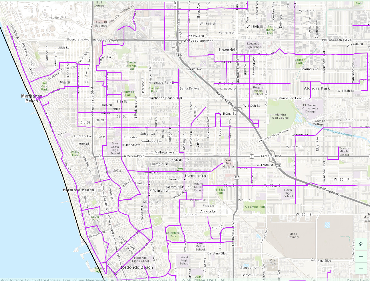
These purple lines are streets/roads where speed limits are 35 mph or less and are not truck routes. But notice how few of them cross the 405 Freeway or any of the high-traffic arterial roads/state highways.
Not only are the legal crossings few and far between, necessitating long detours, but some of those purple streets are one-way. Going in the reverse direction will require an even longer detour. I can't make anything this ludicrous up.
Consider the case of a student in North Redondo Beach who attends Mira Costa High School on an inter-district transfer. (The bus from North RB to RUHS in South RB is jammed and leaves kids stranded at the bus stop. To avoid this, some families beg for an inter-district transfer to the closer MCHS.)
If they had delivered on a bike lane along Artesia Blvd when they repaved it, students could take a direct route with a maximum grade of 5%. Not super pleasant, but doable if you had a protected bike lane. Of course there is no bike lane of any kind because that would have removed free on-street parking. Which is more important than our kids' lives and planetary health.
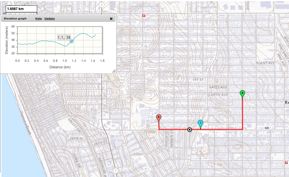 |
| Direct route: 1.6587 km, max 5% grade |
Instead, students must take a roundabout way to an existing traffic light at Robinson/2nd St.
| Westbound detour: 2.2982 km, killer 15% grade short hill |
But Robinson is a 1-way street going westbound, and so is Plant, the only other street connected to the east side of that traffic signal. To get home, our student has to take a different detour that crosses Artesia Blvd (CA 91) twice and Aviation at an angled intersection.
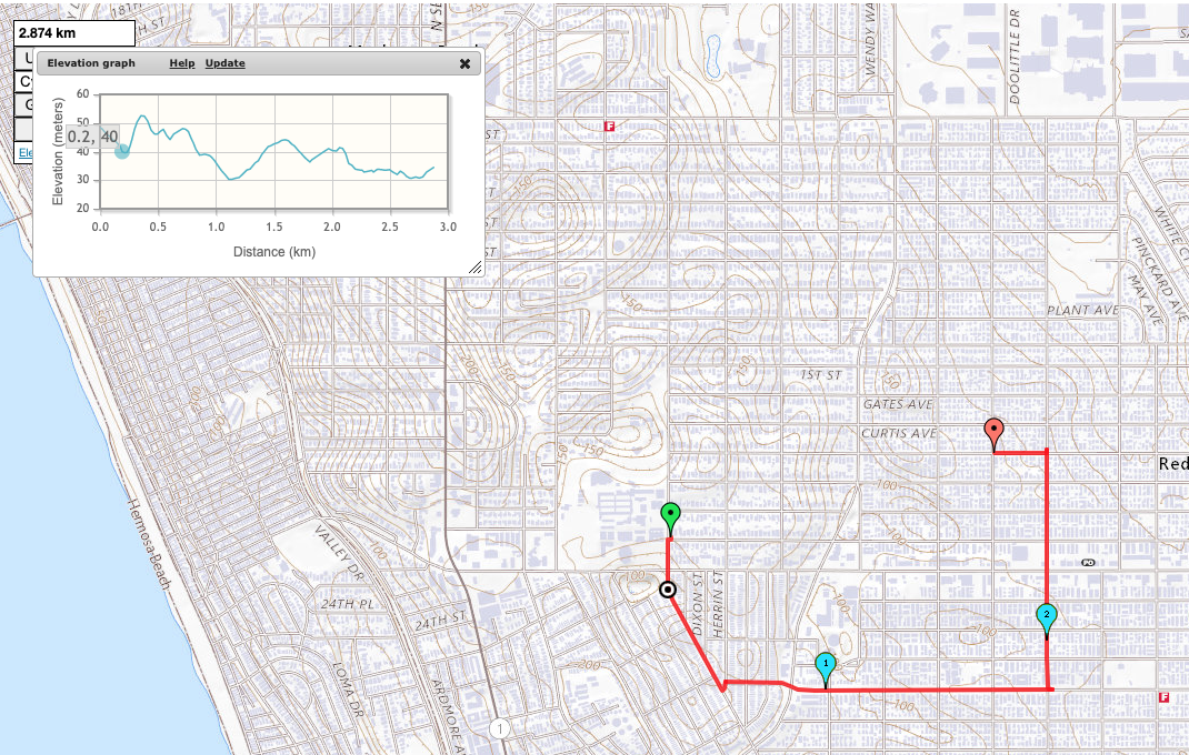 |
| 2.874 km, wheelie territory 15+% grade sustained climb |
If they had built the 2011 Bicycle Master Plan, with a new traffic signal at Voorhees, our student would have had a reversible direct route. There's a 13% grade climb for half a block. But it's doable with an eBike or a very low gear or if they dismount and walk that section.
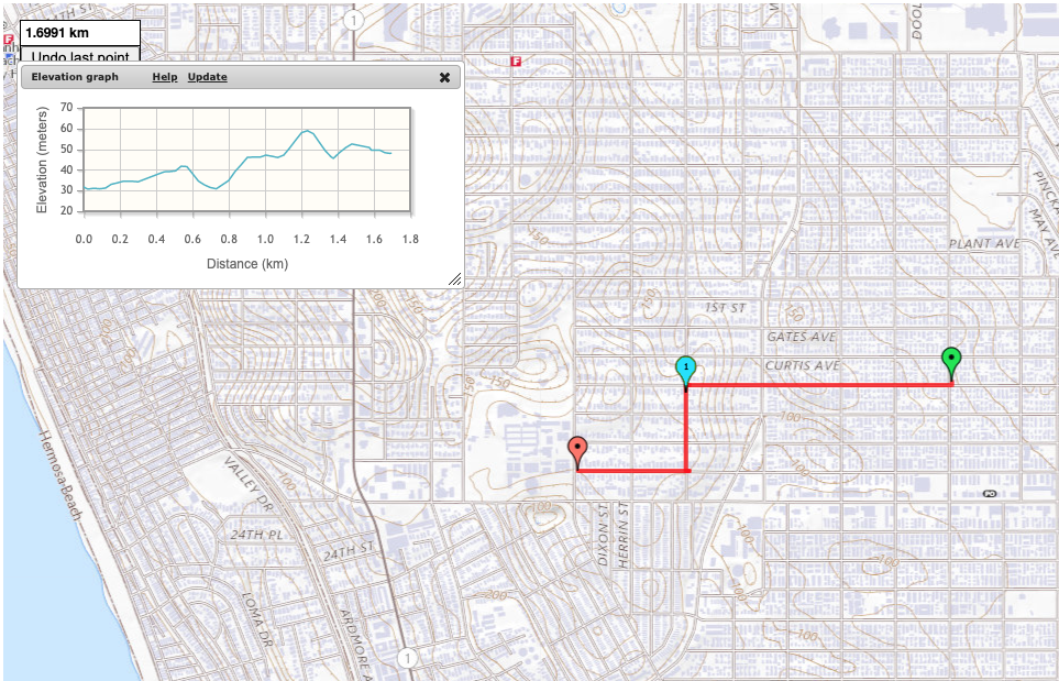 |
| 1.6991 km, max 13% grade |
(I used mappedometer.com in metric to make calculating grades easier. )
In what world do we expect people in an automobile to take a detour that adds 75% more length to their trip and steepens climbs from 5% to 15% grade? That's just abusive.
It's late, so I won't dissect why kids are riding eBikes in all sorts of unsafe ways. Spoiler, it's because the streets are hostile and don't allow them to take more direct and safer routes.
This LTN will not make any difference when completed.
2024 will look a lot like 2022. Only CO2 will be higher still. And we'll have more dead kids*.
* "the crash may have been a result of misaligned crosswalks due to the single diagonal cut handicap ramp, rather than two separate ramps aligned with the crosswalk."
No comments:
Post a Comment
Comments are open for recent posts, but require moderation for posts older than 14 days.