I was discussing Metro's Traffic Reduction Study for pricing roads (aka Congestion Pricing) to discourage driving. This very unambitious plan is targeting just three areas:
DTLA (cordon area)
I-10 between Santa Monica and DTLA (toll road)
I-405 through the Sepulveda pass, including canyon roads (corridor pricing)
I wrote an analysis from a data-based and science (climate change, pollution) perspective, and encountered a lot of pushback. Everyone in the group is a driver, but I'm the only utility bicycle rider that rides in traffic. Others ride recreationally on the beach bike path or on low-traffic foothills roads.
The reflexive response was, "What about the low-income (or moderate income) drivers?"
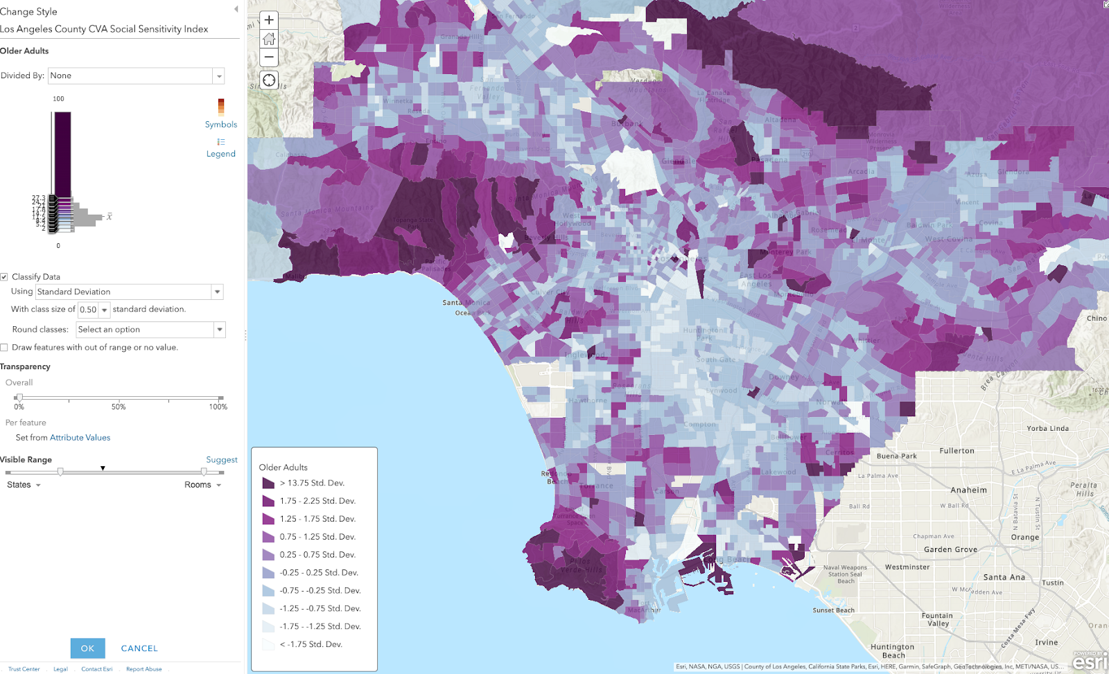
I was making maps using data from Los Angeles County CVA Social Sensitivity Index and was struck by how some areas of LA County are much older than others. That is, the coastal and hill sections have extremely high proportions of seniors. It's especially dramatic if I map the census tracts by how many standard deviations they are from the mean.
Darker magenta areas have more people over 65 years old than average. Bluer areas have fewer seniors.
By implementation time for congestion pricing, today's 65 year olds will be > 73 yo. How long do you think they will be able to drive mountain roads?
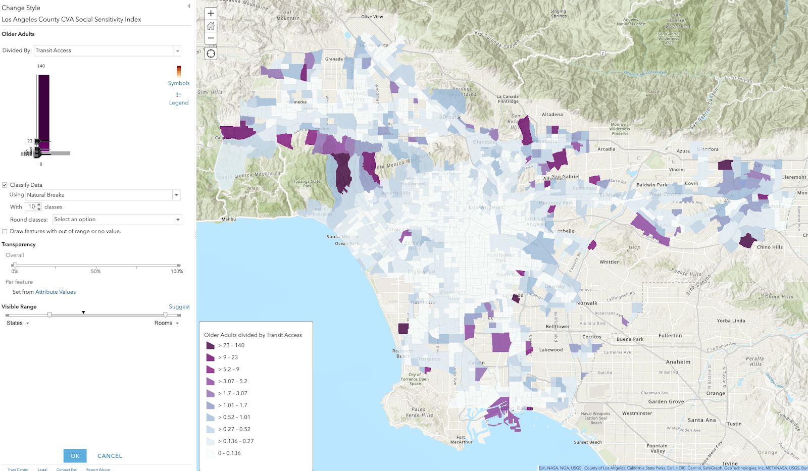
It gets more grim when I divided by transit access. These are high senior population percentage divided by standard deviations from mean transit access (which is already not great in LA County).
Those are areas where we either need to improve transit and micro-mobility (for electric wheelchairs or sit-down scooters), or we need to move seniors out. Because people like to stay near their community, my preference is to coax them down from the canyons to multi-family housing where they are probably already driving for shopping, services, dining, recreation, or work.
This leaves some voids in the flatter areas, which can be fixed by street space allocation, improved bus service, and some apartments near bike lanes & bus routes (hello, East Manhattan Beach).
Anyway, congestion pricing is not going to harm seniors living in the canyons of Bel Air, Malibu, or Brentwood. They will soon age out of driving. It might cost them more to receive senior care in their homes if their caregivers have to pay to drive there.
On the other hand, if it does improve traffic, then lower income workers will have more time for paid work and less unpaid time sitting in traffic. E.g. they can accept more clients per day because they will spend less time driving. This starts a virtue cycle where they won't have to pad their per visit charge as much, making senior care more affordable.
You know what would create less traffic? If we let seniors live in congregate settings, where they each have their own small apartments, but caregivers are on site and can simply walk between clients. That would help alleviate traffic, the shortage of elder caregivers, and improve caregiver pay per hour.
Instead of thinking about changes with fear, look critically at what is not working and how we might improve the status quo.
I need you to fill out a public input survey about a vital active transportation project for Redondo Beach and surrounding cities in the South Bay region of Los Angeles County. This is our chance to reverse some of the damage wrought by past auto-centric road design in North Redondo Beach and allow those who can ride a bike to make school and shopping trips with confidence that they can make it home alive and in one piece.
The current street allocation with car parking on both sides and massive SUVs speeding down our streets is not safe or welcoming for cyclists. The proof is in the declining bicycle mode share.
When filling out the survey, select the options that give a protected bike lane every time. Scroll down past the background info to see my recommendations and why.
Paint is not protection. Never select an option with a paint-only bike lane in the door zone. If someone opens a door, a cyclist in the door zone will be knocked off their bike and suffer grievous injuries. If they swerve to avoid the door, or are knocked into the traffic lane, they could be killed. No one wants to be killed or have their child killed while riding to school.
Two-way cycle tracks are a good option, particularly near schools. When kids are arriving or leaving school, there will be a lot of traffic congestion on all modes. But cars are particularly dangerous. The less car traffic they cross while leaving the congested area, the safer they will be. Keep them on the school side of the street, with wide lanes so that there is passing room in the bikeway (keep the kids out of the car traffic lane).
Plastic poles are not physical protection, but likely the best we can get as a first step. Plastic poles can be replaced with bollards or concrete barriers later if we allow enough buffer space to install the plastic poles in the first place. Do not let the perfect get in the way of actions we can do right now.
You can skip the background (but I hope you read it when you have more time).
Background: The Connection with Schools
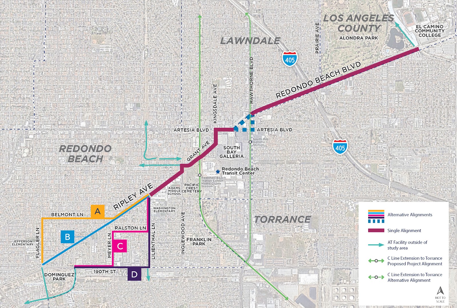
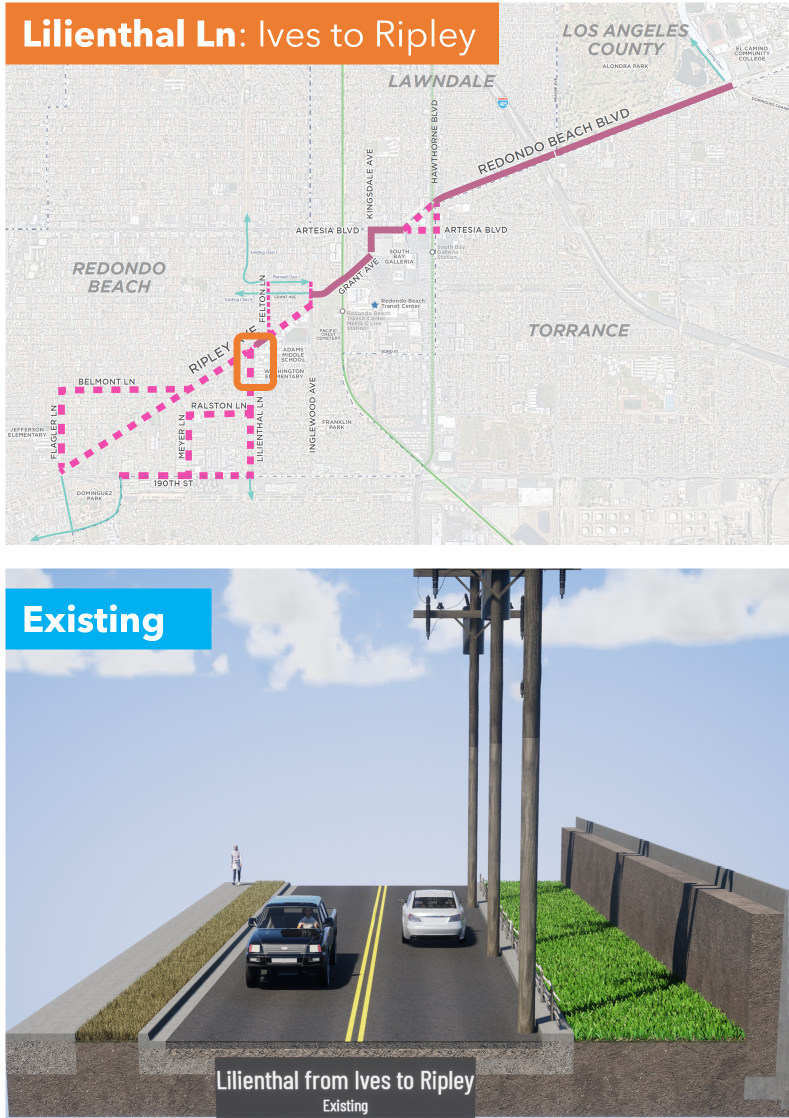
The project area below was originally going to be along the old freight route from Redondo King Harbor to the inland rail routes, but Ripley was found to be too steep (several areas with 15% grades) to be feasible for safe cycling.
A Redondo Beach traffic study determined that 30% of the city's AM/PM peak traffic is the child school run. This travel corridor includes
Adams Middle School: 1066 students: 6-8 grades
Washington Elementary School: 801 students, K-5
Jefferson Elementary School: 509 students, K-5
That's almost 2400 K-12 students arriving and departing each day on this corridor.
But that's not all, because all students in Redondo Beach Unified School District (RBUSD) attend Redondo Union High School (RUHS) in South Redondo Beach*. Jefferson ES students also attend Parras Middle School south of RUHS.
Assuming 350/grade at Adams MS and 90/grade at Jefferson ES,
350*4 + 90*7 = 2030 students cross 190th Street to attend school and return home each day.
About half of all RBUSD students traverse this corridor every school day.
But that's not all; El Camino College (ECC, 22,000 students, many from the Beach Cities) is on the eastern end of this travel corridor. Some RUHS and MCHS students do concurrent enrollment and take classes at ECC while they are in HS. Due to many factors, including cost and lack of housing at UC campuses, a large number of students are enrolling in grades 13/14 at ECC before transferring to a 4-year college/university.
When filling out the survey, think about what you would send your kid to school on. Think about what you would be comfortable riding on as you accompany your younger child to school or run your errands. I ride this area 1-2x/week to run errands in North RB or West Torrance. I want better infrastructure for my safety, too.
Watch this video of the horrifying existing conditions as ridden by two fit MAMILs (Middle-Aged Men in Lycra). Would you ride these steep hills? Next to fast-moving busy traffic?
Here's another video of the area where Kyle, an area father, rides his kids to preschool.
My opinionated guide for the survey choices and why they matter:
Every cross-section shown is facing either Eastbound or Northbound.
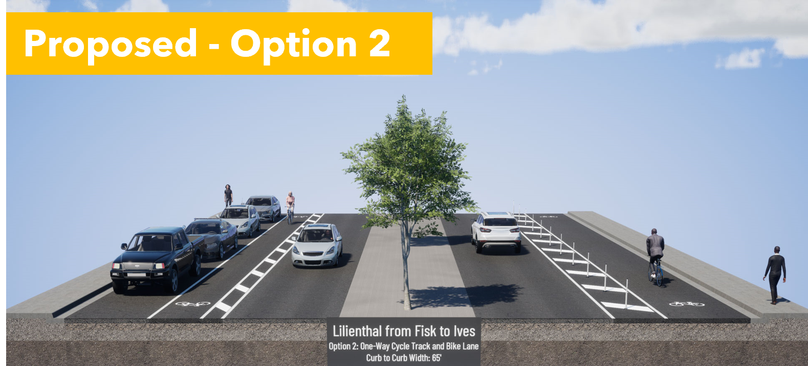
Q1: For the westernmost portion of the corridor, which alignment(s) do you prefer?
I picked D because that would give us a 2-way cycle track on Lilienthal and the longest length of protected bike lanes on 190th. 190th St is also the only way to avoid steep hills.
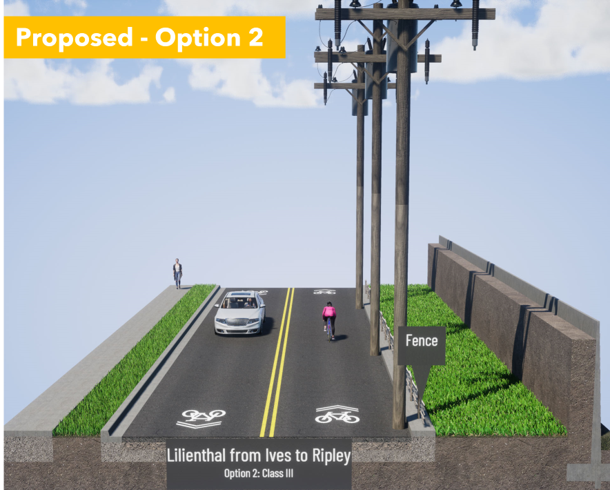
The problem with B: The first video shows just how steep Ripley is. Notice that the lead cyclist on a light road bike has trouble getting up the hill (and the trailing cyclist with the camera is on an eBike). Going up a 15-16% grade is difficult, but going down them is downright dangerous. Do not send kids on this route.
Q2: The proposed street section for 190th St (Alignments C and D) is shown here. How satisfied are you with this proposal?
I picked Very Dissatisfied: These cross-sections are looking towards the east, with Torrance on the Right Hand Side (RHS) and Redondo Beach on the LHS. Cars are coming down the hill from Flagler and often speeding 50 eastbound mph. People drive with the sun in their eyes during the morning and evening commutes. Do you feel safe with just paint and plastic poles designed to bend when run over by vehicles?
I recognize that people living in the apartments in Torrance on the right need overflow parking, but let's swap the bike lane and parking lane. Install a parking-protected bike lane like this one in Long Beach on the Torrance side with breaks to preserve sight lines at each driveway or street crossing.
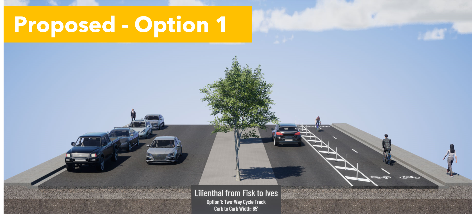
Q3: Select Option 1, the 2-way cycle track on the east side, next to Washington ES.
Option 1 provides separation from cars, and is wide enough for passing, and allows parents to ride side by side with a child gaining confidence in their bike skills. In 2-way cycle tracks, people riding opposing car traffic are facing approaching cars, so they can see and react to dangerous drivers. It would be better to have solid protection here, but Option 1 gives us room to retrofit with more solid barriers later.
Option 2 puts kids in the door zone on one side and makes them cross the street to get to school. It's a dangerous situation.
Q4: Select Option 1, the 2-way cycle track on the east side, next to Washington ES.
Don't be distracted by the stock visualization image with a tall solid wall. There is currently short solid wall on the parking lot side and a wood and rope fence on the road side.
Option 1 gives a clear place for kids to ride that is physically separated from cars. The 2-way cycle track would replace the wide grassy area.
Option 2 is sharrows in a place where drivers are more focused on making a turn at Ripley than cyclists approaching from behind them.
Motorists trying to make a right turn will pull over to the right, trapping cyclists behind them. Small children on bikes and tall, boxy hoods on todays trucks and SUVs mean that parents may not be aware of cyclists in front of them. This has led to an epidemic of frontover crashes where drivers run over people in front of them because they can't see them over their hoods. Or, they look at their screens and forget that there are children in front of them.
Option 2, sharrows, is a safety disaster.
Q5 on Ripley: Pick Option 1, the 2-way cycle track on the Adams MS side
Option 1 keeps the kids on the school side as long as possible. It also preserves the car unloading curb space that people are currently using.
Option 2 puts kids in the door zone, at precisely the time that kids being driven to school are unloading. This is a safety disaster.
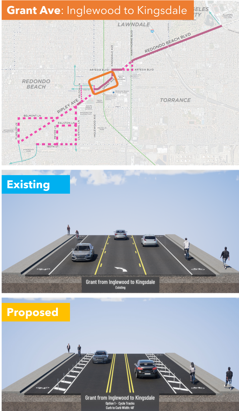
Q6: Grant Ave from Inglewood to Kingsdale; I am very dissatisfied but I selected other and explained why we need solid protection instead of plastic bendy poles
They are proposing paint, a buffered (space separation) and plastic bendy poles.
This is better than existing conditions, but not safe. Cars pick up speed heading downhill and frequently misjudge the curve, so they end up sideswiping cyclists in the bike lane. We really need a concrete barrier on the downhill (right hand) side.
I ride by bike to shop at the Galleria and this is the scariest part. I saw a guy almost get killed here. If we want more people to bike through this area, which connects to shopping, the South Bay Transit Center, and the 300 new homes under construction, then we deserve solid protection in this dangerous area.
I gotta break for lunch but I'm going to hit Publish on this so you can get started. I'll finish after lunch.
...
I'm back. Stay with me because we are on the home stretch, but the most dangerous one that crosses the 405 Freeway and has the most high-speed traffic.
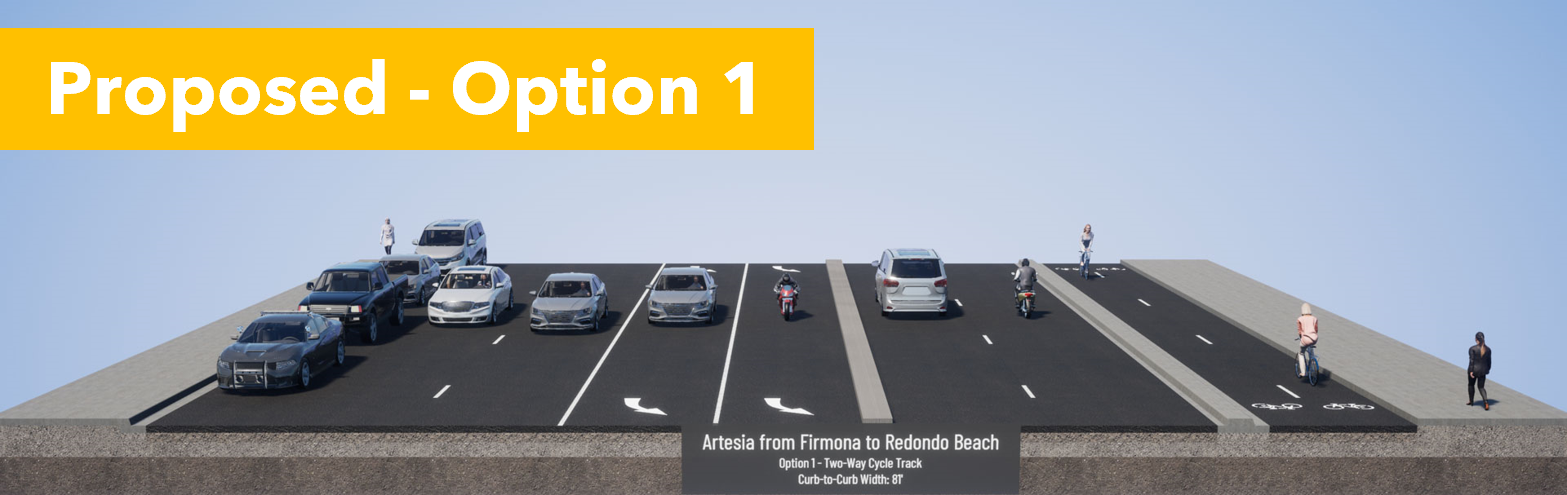
Q7: Artesia Blvd from Kingsdale Ave to Redondo Beach Blvd pick Option 2.
Existing conditions are awful and you see very few cyclists brave enough to ride here. If they do, they are often on the sidewalk, conflicting with pedestrians.
Option 1 puts cyclists next to vehicle lanes, but protected with a concrete curb. Pedestrians and cyclists would intuitively understand where they are supposed to be, as faster bike traffic is at the street level. However, this would interfere with bus stops.
Option 2 puts pedestrians next to the vehicle lanes, but also next to the bus stop. Trees would provide shade. There could be some confusion with pedestrians wandering on the bike path, but that can be solved with good signage.
Our community has experience with pedestrian and bikeways next to each other in the North Redondo Beach Bikeway (NRBB). While there is some spillover, people have already learned where pedestrians and rollers have priority on the NRBB. Option 2 will work best for us and we already know how to use it.
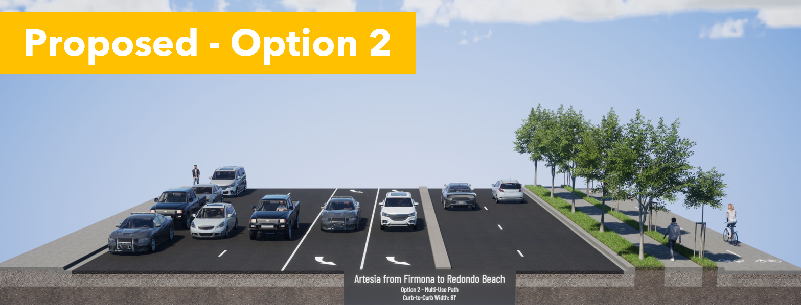
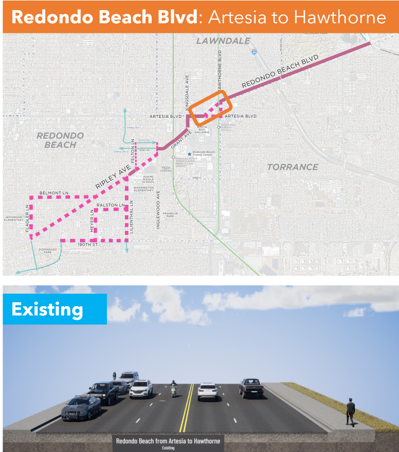
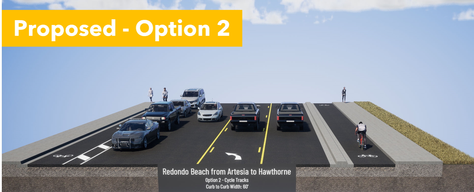
Q8: Redondo Beach Blvd from Artesia Blvd to Hawthorne Blvd. Is a tossup but both Options are so much better than the status quo.
Option 1 pits cyclists against pedestrians, but provides 2-way access to Walgreens and Starbucks. It's not terrible as long as cyclists slow down when passing pedestrians and motorists exiting the parking lots look both ways.
Option 2 provides a clear separation between motorists, cyclists and pedestrians. Cyclists are curb-protected on the eastbound RB side, and parking-protected on the westbound Lawndale side. However, coming westbound from Walgreens/Starbucks, people will likely bike on the sidewalk until they meet the 2-way cycle track.
Although you lose a traffic lane, it's not the cyclists' fault. One can just as easily blame the space allocated to free car storage (on-street parking) and a turn lane. Motorists are losing a travel lane to other motorists, not cyclists. Don't forget that.
Option 1, the 2-way cycle track, provides a better alternative not suggested by Metro for the next section.
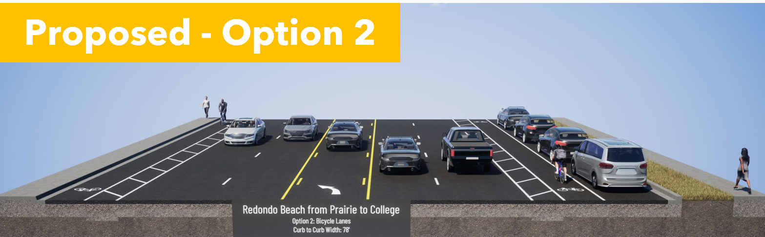
Q9: Redondo Beach Blvd from Hawthorne Blvd to Prairie Ave. I am Very Dissatisfied & propose a better solution.
Although the status quo is very bad, we shouldn't rush into the proposed door zone bike lane next to high-speed traffic heading to the freeway onramps. It is extremely dangerous. This will greatly reduce the number of people brave enough to ride to Alondra Park and El Camino College.
If there is enough room for on-street parking, then there is enough room for a parking-protected bike lane. That may require narrowing the car lanes a bit, but that would also inhibit speeding, making that stretch safer and quieter for all road users.
The freeway onramp is on the north side of RB Blvd. A 2-way cycle track on the south side of RB Blvd would keep cyclists away from the crazy line of cars trying to merge onto the 405 on-ramp. Suggest that in Q11.
Q10: Redondo Beach Blvd from Prairie Ave to Dominguez Channel. Pick Option 1, the 2-way cycle track on the North side, next to the park and El Camino College.
Option 1 puts cyclists next to the park and ECC. Although it is shown with plastic bendy straws, it can easily be fitted with bollards or a concrete curb for better protection when cycling to and from evening classes at ECC.
Option 2 puts cyclists in the door zone, where they can be knocked into fast-moving traffic and killed. Drunk or malicious drivers can also harm cyclists easily with only "paint as protection".
Q11: Additional Comments: This is where we ask for a protected 2-way cycle track on on the south side of RB Blvd between Hawthorne and Prairie.
What do you need to be comfortable bicycling this corridor? Tell them!
Keep in mind that younger Beach Cities kids will probably only ride the western side of this corridor, west of Inglewood or Kingsdale. But older teens and young adults may need to ride to ECC or to retail jobs between Kingsdale and Crenshaw.
There are a lot of children and seniors in Lawndale and Torrance who would benefit from these bike facilities, whether they are riding a bike, trike or mobility scooter.
We should make this corridor welcoming for ages 8-80.
Think about who needs to travel through this corridor and at what times. What kind of cycling facilities do they need to get there comfortably and safely? What about seniors in mobility scooters or electric wheelchairs? Would you like to see food delivery robots in the bike lane or more food delivery by privately-owned cars?
With better bike facilities, I may choose to bike to stores further east than I currently feel safe. Every trip I make by eBike instead of car, I am "sparing the air", not taking up road space in front of you, and not competing with you for parking.
Another thing that excites me about this project is that it connects us to the Dominguez Channel. In a separate project, LA County Public Works will be extending the bike path along the channel southwards. It currently goes north to 120th St, past Amazon, Space-X, Lowe's and to the Metro Green/C Line. A southbound channel bike path would connect to the Harbor Gateway Transit Center, with very fast connections to the Silver/J Line to USC/Expo Park (15 min) and Downtown LA (20 min). Harbor Gateway TS is already linked up to CSU Dominguez Hills. This is a large step forward for a transportation transformation for the South Bay.
Bike lanes benefit you even if you don't ride a bike, but your neighbors do.
Bike lanes will save you time currently spent chauffeuring your kids short distances.
Bike lanes will benefit your kids because students who get exercise before school do better.
Bike lanes will benefit you when you age out of driving.
This bike corridor will touch the lives of half the students in RBUSD and can be transformative for the way our community gets around. If half of our households can shed just one car, we would be richer, our street parking and traffic congestion problems will evaporate, our air and water will be cleaner, and we will have done our part to slow climate change. Oh, we'll be fitter and happier, too.
* A very few students living in North RB attend Mira Costa HS in Manhattan Beach, but only if MBUSD will take them.
This post was inspired by a Twitter exchange with a Culver City resident who was able to shed one of her family's two cars due to the Move Culver City Project to reallocate space from cars to transit (bus lanes), active transportation (walking/biking) and micro-mobility (scooters, wheelchairs).
Culver City's city council balance changed from 3/2 in support of this street space reallocation to 3/2 opposed. The new city council wants to reverse the street space allocation and give 100% of the public space to cars again despite the city's own data that transit and bike use grew explosively while car use declined. Read the Move Culver City Mid-Pilot Report.
I think reversing Move Culver City is a big mistake for many reasons, but I will just get into the financial angle in this post.
Car ownership is so normalized in US society that I think we stop paying attention to how much it's really costing us. When AAA published their annual report "How Much Does it Really Cost to Own a New Car 2022", it surprised many people. [2023 Update is even grimmer, $12,182/year]
$10,728 is an underestimate for the cost to own a car in Los Angeles. That price also does not include the cost of a parking spot, which you are paying for whether it's a line item in your budget or not. Everyone seems to complain about parking, even though Los Angeles has more homes for cars than for people.
If households with multiple cars can shed one car, they can save $10,728/year.
Median Culver City household income in $97,540 with a marginal tax rate (CA+Fed) of 33.3%.
Owning a car costs $16,084/year pre-tax.
If that money were put in a tax-deferred retirement savings account every year for 30 years, that household can accumulate just under $1 Million!
Using a conservative 4% above inflation estimate for VGIAX, the Bankrate Compound Interest Calculator shows that the household that was able to shed a car winds up with $916,300 after 30 years in their retirement savings account. Yes, you do pay taxes as you withdraw that money, but that's a huge chunk of money nevertheless.
In Summary, if Move Culver City allows families to shed one car, then that is a $1M gift to the families in Culver City.
Reversing/removing the street improvements--making buses too slow to use and bicycling too dangerous to attempt--forces families into cars again. If they have to own a second car again, then Culver City families lose $1 M.
Elected officials should think long and hard about whether they want to force car dependency and costs onto their residents. It's not good for residents, it's not good for the planet, it's not good for the city. Finally, I don't think it's good for the elected officials' ability to get re-elected.