There is so much I want to tell you about my beloved California and the danger it faces from people with lawyers, lobbyists and PR staff working to bleed it dry before everyone else notices.
You've probably read the headlines about the three years with nearly no precipitation and quotes by people who say it is just random chance or god's fault. The truth is much more complex. But, as a scientist and a Californian with a love for the outdoors, I can clearly see that this is a man-made disaster and the culprit is not Carly Fiorina's conveniently mute scapegoat.
Firstly, California is mostly dry for over half the year. We get most of our rain and snow between October-April, when the atmospheric high pressure dome called the Pacific High moves south. Only then can moist air masses from the ocean reach California instead of being deflected to the north.
The past 2-3 years, the Ridiculously Resilient Ridge has not budged even during the winter, causing our perpetual (and dry) summer.
 |
| Google Earth depiction of Landsat imagery of California showing the mountains and valleys. |
It was estimated that 30-40% of California's water usage came from groundwater. However, the amount is murky because there are no rules governing groundwater pumping and even where users are required to self-report the extent of their groundwater pumping, the data is kept secret to protect the privacy of water users.
Read the background information in If You Think the Water Crisis Can't Get Worse, Wait Until the Aquifers Are Drained and weep.
Groundwater comes from aquifers—spongelike gravel and sand-filled underground reservoirs—and we see this water only when it flows from springs and wells. In the United States we rely on this hidden—and shrinking—water supply to meet half our needs, and as drought shrinks surface water in lakes, rivers, and reservoirs, we rely on groundwater from aquifers even more. Some shallow aquifers recharge from surface water, but deeper aquifers contain ancient water locked in the earth by changes in geology thousands or millions of years ago. These aquifers typically cannot recharge, and once this "fossil" water is gone, it is gone forever—potentially changing how and where we can live and grow food, among other things.How bad is it? In the past, we didn't know. Even where self-reporting was required, how could we check the accuracy of water users' self-reported usage?
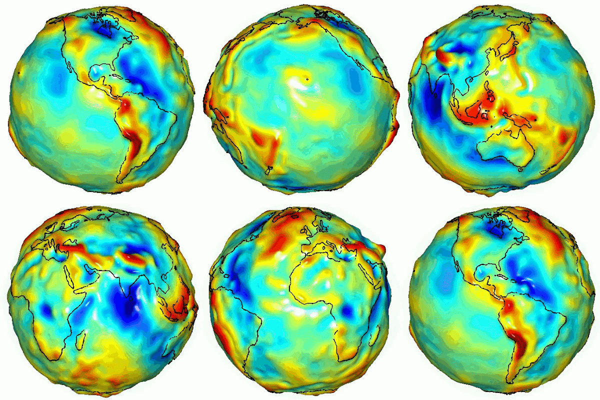
We can measure the Earth's gravitational field--and hence it's mass distribution--so accurately from space, that we actually know the answer. Weighing Earth's Water from Space (written in 2003) gives an excellent background of the technique (be sure to click through all three pages).
 |
| "Potsdam Potato" vertically exaggerated depiction of the earth's gravity field or mass distribution. |
 |
| Global visualization of a gravity model created with data from NASA's Gravity Recovery and Climate Experiment (GRACE) showing variations in Earth’s gravity field. |
A smart and resilient society would treat the aquifers as a piggy bank. Bank water during wet years and then withdraw during the dry ones. Instead, we've been drawing unsustainably even during the wet years. We are simply living beyond our means.
 |
| Grace observed trends in groundwater levels, October, 2003 – March, 2009Image Credit: University Of California Center For Hydrologic Modeling via JPL. |
 |
| Integrate these groundwater depletion trends a decade or so and you can understand why portions of the Central Valley have sunk 30 feet. |
Remember the part above about "spongelike gravel"? Dry out a sponge and it shrinks. Portions of the Central Valley (CV) have sunk 30 feet--often to below sea level. Unlike a sponge which can swell up when wetted, ground compaction is permanent. That means the sunken areas are permanently sunk.
The economic gains from groundwater depletion go to a very few. Don't let the pictures of unemployed farm laborers fool you. They weren't making much money even during the wet years. The money flowed to a very, very small group of (mostly corporate and/or absentee) landowners.
Having privatized the water beneath all of us, they socialize all the costs by sticking it to the rest of us to pay for the infrastructure destroyed by the sinking ground. More about that.
From the SJ Mercury:
NEW GROUNDWATER RULESThe moneybags with the lobbyists got everything they wanted. By 2040, the aquifer that took millions of years to form will be completely dry at the rate they are using it up.
The groundwater legislation signed by Gov. Jerry Brown on Tuesday requires local water agencies to replenish underground aquifers that have been depleted. Farmers will likely have to meter their wells, and some may be forced to cease or dramatically reduce pumping.By 2017, groundwater management agencies must be created across California.
By 2020, groundwater basins that are "overdrafted" (meaning more water is being pumped than replenished) must have "sustainability plans."
By 2022, all other basins must have such plans.
By 2040, all "high and medium priority" basins must achieve sustainability.
Then there are the atmospheric rivers I mentioned earlier. Read Lynn Ingram's California Megaflood: Lessons from a Forgotten Catastrophe about a two-month series of storms that submerged Sacramento and the Central Valley for months. It would be even worse today because groundwater pumping has lowered the CV 30 feet below the 1862 level.
BTW, California's population is growing fastest in the lowest-lying areas.
Are you as worried as I am? How do we stop the bullshit?
One of the most informative and most frightening articles I've read. Would you consider instigating a proposition to either repeal or amend the groundwater legislation signed by Brown to fast track the implementation of these agencies and/or collapse the implementation timeline? Or maybe even launching a petition on change.org?
ReplyDeleteUnfortunately, that's only a small fraction of the bad water news. Stay tuned.
DeleteMy plate is too full to spearhead a movement. But, please do get the word out and stay tuned for more water science.